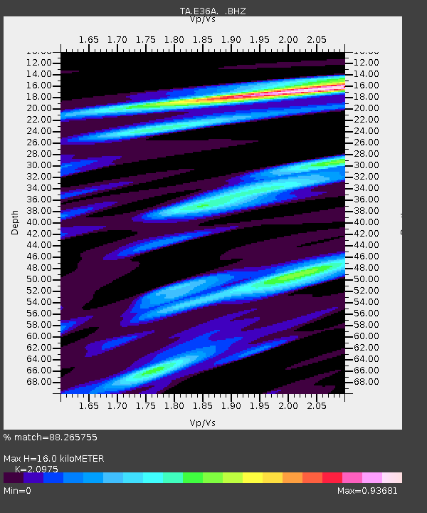
E36A McGregor, MN, USA - Earthquake Result Viewer
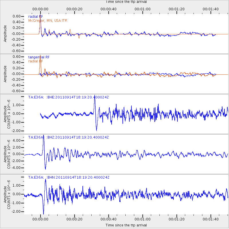
Earthquake location: Near Islands, Aleutian Islands
Earthquake latitude/longitude: 53.1/173.0
Earthquake time(UTC): 2011/09/14 (257) 18:10:09 GMT
Earthquake Depth: 15 km
Earthquake Magnitude: 6.1 MB, 5.7 MS, 6.0 MW, 6.0 MW
Earthquake Catalog/Contributor: WHDF/NEIC
Network: TA USArray Transportable Network (new EarthScope stations)
Station: E36A McGregor, MN, USA
Lat/Lon: 46.52 N/93.26 W
Elevation: 393 m
Distance: 56.7 deg
Az: 55.579 deg
Baz: 313.93 deg
Ray Param: 0.063990824
Estimated Moho Depth: 16.0 km
Estimated Crust Vp/Vs: 2.10
Assumed Crust Vp: 6.571 km/s
Estimated Crust Vs: 3.133 km/s
Estimated Crust Poisson's Ratio: 0.35
Radial Match: 88.265755 %
Radial Bump: 400
Transverse Match: 69.61926 %
Transverse Bump: 400
SOD ConfigId: 414626
Insert Time: 2012-01-23 10:48:35.132 +0000
GWidth: 2.5
Max Bumps: 400
Tol: 0.001

Signal To Noise

ChannelStoNSTALTA
TA:E36A: :BHZ:20110914T18:19:20.400024Z17.4102212.2941397E-61.3176971E-7
TA:E36A: :BHN:20110914T18:19:20.400024Z7.83307088.992729E-71.1480464E-7
TA:E36A: :BHE:20110914T18:19:20.400024Z5.41060169.2961625E-71.7181384E-7
Arrivals
Ps2.8 SECOND
PpPs7.2 SECOND
PsPs/PpSs10 SECOND