F32A Veblen, SD, USA - Earthquake Result Viewer
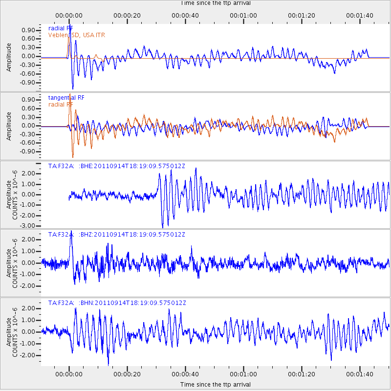
Earthquake location: Near Islands, Aleutian Islands
Earthquake latitude/longitude: 53.1/173.0
Earthquake time(UTC): 2011/09/14 (257) 18:10:09 GMT
Earthquake Depth: 15 km
Earthquake Magnitude: 6.1 MB, 5.7 MS, 6.0 MW, 6.0 MW
Earthquake Catalog/Contributor: WHDF/NEIC
Network: TA USArray Transportable Network (new EarthScope stations)
Station: F32A Veblen, SD, USA
Lat/Lon: 45.87 N/97.13 W
Elevation: 371 m
Distance: 55.1 deg
Az: 58.375 deg
Baz: 312.713 deg
Ray Param: 0.064978994
Estimated Moho Depth: 15.75 km
Estimated Crust Vp/Vs: 1.94
Assumed Crust Vp: 6.552 km/s
Estimated Crust Vs: 3.378 km/s
Estimated Crust Poisson's Ratio: 0.32
Radial Match: 83.19346 %
Radial Bump: 400
Transverse Match: 73.53709 %
Transverse Bump: 400
SOD ConfigId: 414626
Insert Time: 2012-01-23 10:49:04.159 +0000
GWidth: 2.5
Max Bumps: 400
Tol: 0.001

Signal To Noise

ChannelStoNSTALTA
TA:F32A: :BHZ:20110914T18:19:09.575012Z5.32426931.0806426E-62.0296544E-7
TA:F32A: :BHN:20110914T18:19:09.575012Z3.35803999.149388E-72.7246216E-7
TA:F32A: :BHE:20110914T18:19:09.575012Z6.206581.4830907E-62.3895458E-7
Arrivals
Ps2.4 SECOND
PpPs6.7 SECOND
PsPs/PpSs9.1 SECOND