You are here: Home > Network List > TA - USArray Transportable Network (new EarthScope stations) Stations List
> Station L36A Harm Buss Farm, Glidden, IA, USA > Earthquake Result Viewer
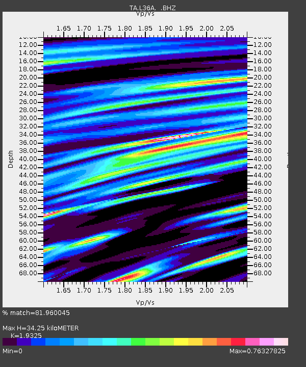
L36A Harm Buss Farm, Glidden, IA, USA - Earthquake Result Viewer
| Earthquake location: |
Near Islands, Aleutian Islands |
| Earthquake latitude/longitude: |
53.1/173.0 |
| Earthquake time(UTC): |
2011/09/14 (257) 18:10:09 GMT |
| Earthquake Depth: |
15 km |
| Earthquake Magnitude: |
6.1 MB, 5.7 MS, 6.0 MW, 6.0 MW |
| Earthquake Catalog/Contributor: |
WHDF/NEIC |
|
| Network: |
TA USArray Transportable Network (new EarthScope stations) |
| Station: |
L36A Harm Buss Farm, Glidden, IA, USA |
| Lat/Lon: |
42.10 N/94.67 W |
| Elevation: |
353 m |
|
| Distance: |
59.0 deg |
| Az: |
60.131 deg |
| Baz: |
315.371 deg |
| Ray Param: |
0.062443804 |
| Estimated Moho Depth: |
34.25 km |
| Estimated Crust Vp/Vs: |
1.93 |
| Assumed Crust Vp: |
6.53 km/s |
| Estimated Crust Vs: |
3.379 km/s |
| Estimated Crust Poisson's Ratio: |
0.32 |
|
| Radial Match: |
81.960045 % |
| Radial Bump: |
400 |
| Transverse Match: |
73.55955 % |
| Transverse Bump: |
400 |
| SOD ConfigId: |
414626 |
| Insert Time: |
2012-01-23 10:49:46.056 +0000 |
| GWidth: |
2.5 |
| Max Bumps: |
400 |
| Tol: |
0.001 |
|

Signal To Noise
| Channel | StoN | STA | LTA |
| TA:L36A: :BHZ:20110914T18:19:37.099976Z | 11.305364 | 1.5289264E-6 | 1.3523903E-7 |
| TA:L36A: :BHN:20110914T18:19:37.099976Z | 3.2795856 | 6.468944E-7 | 1.9724884E-7 |
| TA:L36A: :BHE:20110914T18:19:37.099976Z | 2.565457 | 5.276006E-7 | 2.0565558E-7 |
| Arrivals |
| Ps | 5.1 SECOND |
| PpPs | 15 SECOND |
| PsPs/PpSs | 20 SECOND |


