You are here: Home > Network List > TA - USArray Transportable Network (new EarthScope stations) Stations List
> Station Q39A Willow Grove Farm, Nelson, MO, USA > Earthquake Result Viewer
Q39A Willow Grove Farm, Nelson, MO, USA - Earthquake Result Viewer
| Earthquake location: |
Near Islands, Aleutian Islands |
| Earthquake latitude/longitude: |
53.1/173.0 |
| Earthquake time(UTC): |
2011/09/14 (257) 18:10:09 GMT |
| Earthquake Depth: |
15 km |
| Earthquake Magnitude: |
6.1 MB, 5.7 MS, 6.0 MW, 6.0 MW |
| Earthquake Catalog/Contributor: |
WHDF/NEIC |
|
| Network: |
TA USArray Transportable Network (new EarthScope stations) |
| Station: |
Q39A Willow Grove Farm, Nelson, MO, USA |
| Lat/Lon: |
39.05 N/92.98 W |
| Elevation: |
225 m |
|
| Distance: |
62.1 deg |
| Az: |
61.485 deg |
| Baz: |
317.132 deg |
| Ray Param: |
0.060418654 |
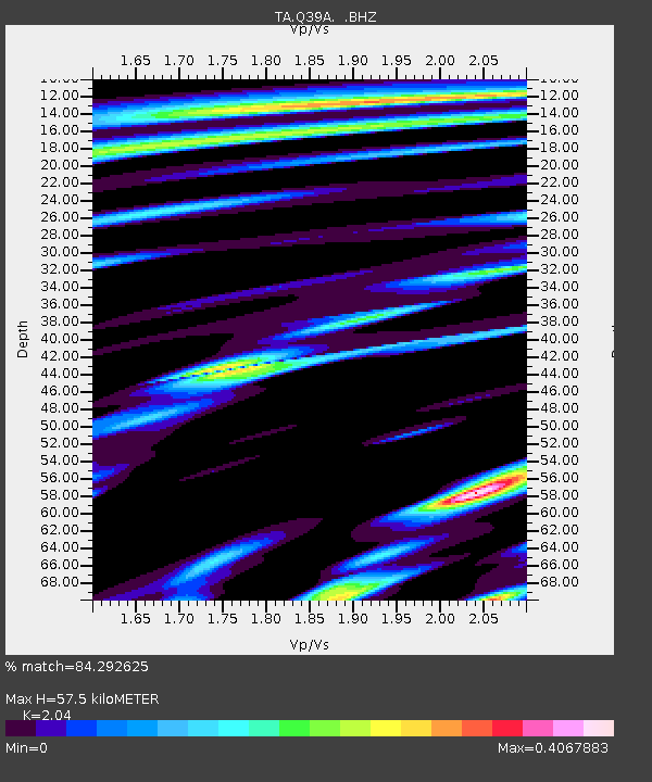
| Estimated Moho Depth: |
57.5 km |
| Estimated Crust Vp/Vs: |
2.04 |
| Assumed Crust Vp: |
6.498 km/s |
| Estimated Crust Vs: |
3.185 km/s |
| Estimated Crust Poisson's Ratio: |
0.34 |
|
| Radial Match: |
84.292625 % |
| Radial Bump: |
400 |
| Transverse Match: |
61.99122 % |
| Transverse Bump: |
400 |
| SOD ConfigId: |
414626 |
| Insert Time: |
2012-01-23 10:51:09.353 +0000 |
| GWidth: |
2.5 |
| Max Bumps: |
400 |
| Tol: |
0.001 |
|

Signal To Noise
| Channel | StoN | STA | LTA |
| TA:Q39A: :BHZ:20110914T18:19:58.174988Z | 8.198996 | 1.4467647E-6 | 1.7645633E-7 |
| TA:Q39A: :BHN:20110914T18:19:58.174988Z | 3.9951994 | 4.1636352E-7 | 1.0421595E-7 |
| TA:Q39A: :BHE:20110914T18:19:58.174988Z | 4.5907216 | 5.969855E-7 | 1.3004176E-7 |
| Arrivals |
| Ps | 9.6 SECOND |
| PpPs | 26 SECOND |
| PsPs/PpSs | 35 SECOND |


