You are here: Home > Network List > TA - USArray Transportable Network (new EarthScope stations) Stations List
> Station W40A Ferguson Farm, Pottsville, AR, USA > Earthquake Result Viewer
W40A Ferguson Farm, Pottsville, AR, USA - Earthquake Result Viewer
| Earthquake location: |
Near Islands, Aleutian Islands |
| Earthquake latitude/longitude: |
53.1/173.0 |
| Earthquake time(UTC): |
2011/09/14 (257) 18:10:09 GMT |
| Earthquake Depth: |
15 km |
| Earthquake Magnitude: |
6.1 MB, 5.7 MS, 6.0 MW, 6.0 MW |
| Earthquake Catalog/Contributor: |
WHDF/NEIC |
|
| Network: |
TA USArray Transportable Network (new EarthScope stations) |
| Station: |
W40A Ferguson Farm, Pottsville, AR, USA |
| Lat/Lon: |
35.19 N/93.07 W |
| Elevation: |
108 m |
|
| Distance: |
64.9 deg |
| Az: |
64.435 deg |
| Baz: |
318.392 deg |
| Ray Param: |
0.05859579 |
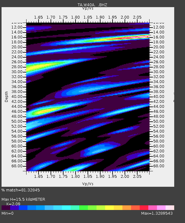
| Estimated Moho Depth: |
15.5 km |
| Estimated Crust Vp/Vs: |
2.09 |
| Assumed Crust Vp: |
6.498 km/s |
| Estimated Crust Vs: |
3.109 km/s |
| Estimated Crust Poisson's Ratio: |
0.35 |
|
| Radial Match: |
81.32845 % |
| Radial Bump: |
400 |
| Transverse Match: |
77.66128 % |
| Transverse Bump: |
400 |
| SOD ConfigId: |
414626 |
| Insert Time: |
2012-01-23 10:52:35.565 +0000 |
| GWidth: |
2.5 |
| Max Bumps: |
400 |
| Tol: |
0.001 |
|
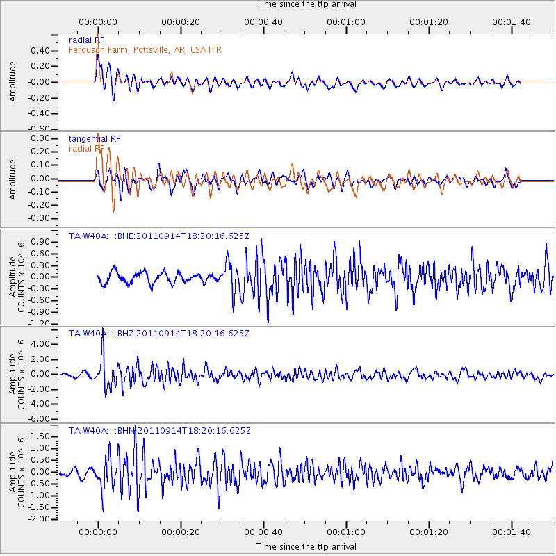
Signal To Noise
| Channel | StoN | STA | LTA |
| TA:W40A: :BHZ:20110914T18:20:16.625Z | 10.851682 | 2.0229697E-6 | 1.8641994E-7 |
| TA:W40A: :BHN:20110914T18:20:16.625Z | 5.962353 | 6.4956527E-7 | 1.0894445E-7 |
| TA:W40A: :BHE:20110914T18:20:16.625Z | 2.9293811 | 3.9406785E-7 | 1.3452257E-7 |
| Arrivals |
| Ps | 2.7 SECOND |
| PpPs | 7.1 SECOND |
| PsPs/PpSs | 9.8 SECOND |


