You are here: Home > Network List > TA - USArray Transportable Network (new EarthScope stations) Stations List
> Station X39A Fountain Ranch, Mena, AR, USA > Earthquake Result Viewer
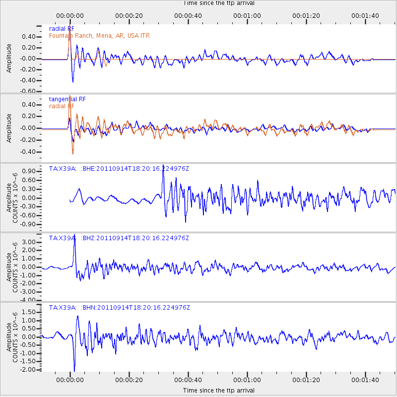
X39A Fountain Ranch, Mena, AR, USA - Earthquake Result Viewer
*The percent match for this event was below the threshold and hence no stack was calculated.
| Earthquake location: |
Near Islands, Aleutian Islands |
| Earthquake latitude/longitude: |
53.1/173.0 |
| Earthquake time(UTC): |
2011/09/14 (257) 18:10:09 GMT |
| Earthquake Depth: |
15 km |
| Earthquake Magnitude: |
6.1 MB, 5.7 MS, 6.0 MW, 6.0 MW |
| Earthquake Catalog/Contributor: |
WHDF/NEIC |
|
| Network: |
TA USArray Transportable Network (new EarthScope stations) |
| Station: |
X39A Fountain Ranch, Mena, AR, USA |
| Lat/Lon: |
34.51 N/94.11 W |
| Elevation: |
326 m |
|
| Distance: |
64.9 deg |
| Az: |
65.643 deg |
| Baz: |
318.31 deg |
| Ray Param: |
$rayparam |
*The percent match for this event was below the threshold and hence was not used in the summary stack. |
|
| Radial Match: |
75.34958 % |
| Radial Bump: |
400 |
| Transverse Match: |
73.31186 % |
| Transverse Bump: |
400 |
| SOD ConfigId: |
414626 |
| Insert Time: |
2012-01-23 10:52:53.226 +0000 |
| GWidth: |
2.5 |
| Max Bumps: |
400 |
| Tol: |
0.001 |
|
Signal To Noise
| Channel | StoN | STA | LTA |
| TA:X39A: :BHZ:20110914T18:20:16.224976Z | 11.856133 | 1.2929978E-6 | 1.0905729E-7 |
| TA:X39A: :BHN:20110914T18:20:16.224976Z | 5.355387 | 7.223136E-7 | 1.3487607E-7 |
| TA:X39A: :BHE:20110914T18:20:16.224976Z | 3.7868898 | 3.9909415E-7 | 1.05388374E-7 |
| Arrivals |
| Ps | |
| PpPs | |
| PsPs/PpSs | |


