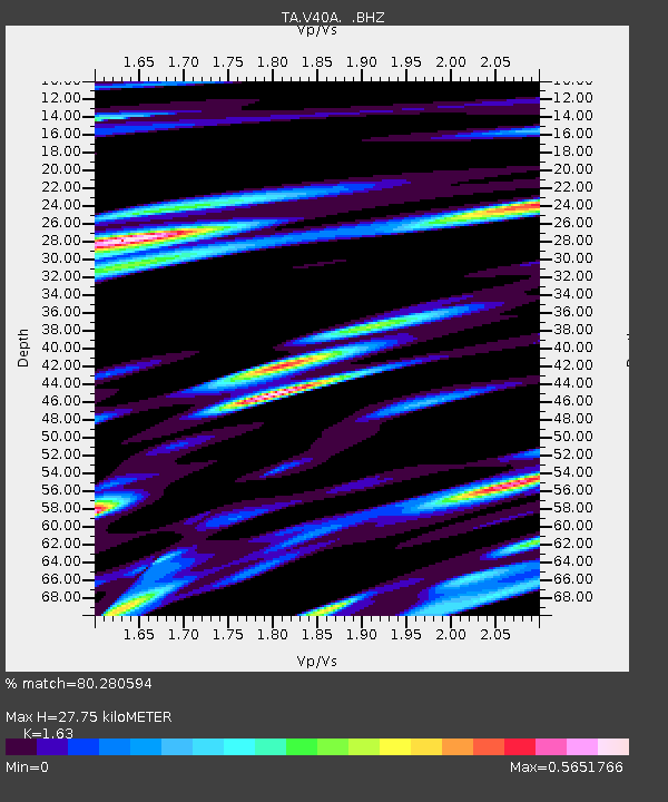
V40A Witts Springs, AR, USA - Earthquake Result Viewer

Earthquake location: Near Islands, Aleutian Islands
Earthquake latitude/longitude: 53.1/173.0
Earthquake time(UTC): 2011/09/14 (257) 18:10:09 GMT
Earthquake Depth: 15 km
Earthquake Magnitude: 6.1 MB, 5.7 MS, 6.0 MW, 6.0 MW
Earthquake Catalog/Contributor: WHDF/NEIC
Network: TA USArray Transportable Network (new EarthScope stations)
Station: V40A Witts Springs, AR, USA
Lat/Lon: 35.80 N/92.82 W
Elevation: 570 m
Distance: 64.6 deg
Az: 63.82 deg
Baz: 318.272 deg
Ray Param: 0.058804072
Estimated Moho Depth: 27.75 km
Estimated Crust Vp/Vs: 1.63
Assumed Crust Vp: 6.498 km/s
Estimated Crust Vs: 3.986 km/s
Estimated Crust Poisson's Ratio: 0.20
Radial Match: 80.280594 %
Radial Bump: 400
Transverse Match: 68.21279 %
Transverse Bump: 400
SOD ConfigId: 414626
Insert Time: 2012-01-23 10:54:48.583 +0000
GWidth: 2.5
Max Bumps: 400
Tol: 0.001

Signal To Noise

ChannelStoNSTALTA
TA:V40A: :BHZ:20110914T18:20:14.525024Z12.8566761.2977661E-61.0094103E-7
TA:V40A: :BHN:20110914T18:20:14.525024Z7.889555.815798E-77.3715206E-8
TA:V40A: :BHE:20110914T18:20:14.525024Z5.7372885.246215E-79.144068E-8
Arrivals
Ps2.8 SECOND
PpPs11 SECOND
PsPs/PpSs14 SECOND