You are here: Home > Network List > TA - USArray Transportable Network (new EarthScope stations) Stations List
> Station Z43A Armstrong Family, Eudora, AR, USA > Earthquake Result Viewer
Z43A Armstrong Family, Eudora, AR, USA - Earthquake Result Viewer
| Earthquake location: |
Near Islands, Aleutian Islands |
| Earthquake latitude/longitude: |
53.1/173.0 |
| Earthquake time(UTC): |
2011/09/14 (257) 18:10:09 GMT |
| Earthquake Depth: |
15 km |
| Earthquake Magnitude: |
6.1 MB, 5.7 MS, 6.0 MW, 6.0 MW |
| Earthquake Catalog/Contributor: |
WHDF/NEIC |
|
| Network: |
TA USArray Transportable Network (new EarthScope stations) |
| Station: |
Z43A Armstrong Family, Eudora, AR, USA |
| Lat/Lon: |
33.21 N/91.24 W |
| Elevation: |
39 m |
|
| Distance: |
67.4 deg |
| Az: |
64.607 deg |
| Baz: |
319.483 deg |
| Ray Param: |
0.056962427 |
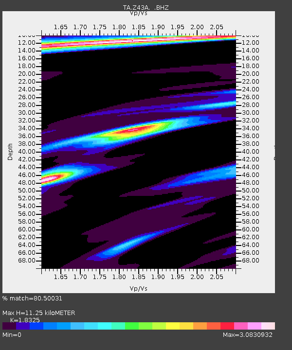
| Estimated Moho Depth: |
11.25 km |
| Estimated Crust Vp/Vs: |
1.83 |
| Assumed Crust Vp: |
6.201 km/s |
| Estimated Crust Vs: |
3.384 km/s |
| Estimated Crust Poisson's Ratio: |
0.29 |
|
| Radial Match: |
80.50031 % |
| Radial Bump: |
391 |
| Transverse Match: |
73.874985 % |
| Transverse Bump: |
400 |
| SOD ConfigId: |
414626 |
| Insert Time: |
2012-01-23 10:57:42.504 +0000 |
| GWidth: |
2.5 |
| Max Bumps: |
400 |
| Tol: |
0.001 |
|
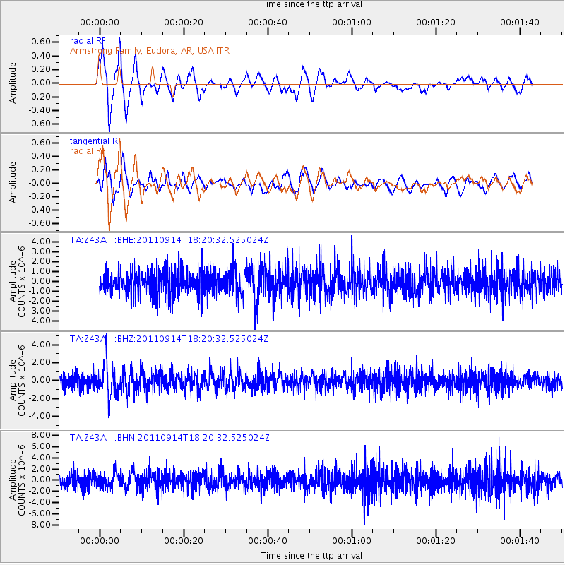
Signal To Noise
| Channel | StoN | STA | LTA |
| TA:Z43A: :BHZ:20110914T18:20:32.525024Z | 2.7903194 | 1.7808698E-6 | 6.382315E-7 |
| TA:Z43A: :BHN:20110914T18:20:32.525024Z | 1.0861033 | 1.2099508E-6 | 1.1140291E-6 |
| TA:Z43A: :BHE:20110914T18:20:32.525024Z | 1.0638958 | 1.2312196E-6 | 1.1572745E-6 |
| Arrivals |
| Ps | 1.6 SECOND |
| PpPs | 5.0 SECOND |
| PsPs/PpSs | 6.5 SECOND |


