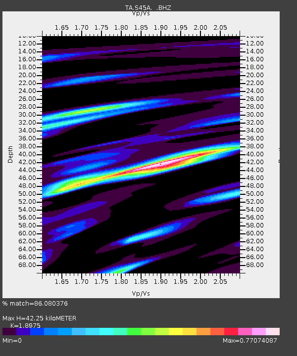
S45A Carrier Mills, IL, USA - Earthquake Result Viewer

Earthquake location: Near Islands, Aleutian Islands
Earthquake latitude/longitude: 53.1/173.0
Earthquake time(UTC): 2011/09/14 (257) 18:10:09 GMT
Earthquake Depth: 15 km
Earthquake Magnitude: 6.1 MB, 5.7 MS, 6.0 MW, 6.0 MW
Earthquake Catalog/Contributor: WHDF/NEIC
Network: TA USArray Transportable Network (new EarthScope stations)
Station: S45A Carrier Mills, IL, USA
Lat/Lon: 37.68 N/88.58 W
Elevation: 122 m
Distance: 65.5 deg
Az: 59.636 deg
Baz: 319.033 deg
Ray Param: 0.058250107
Estimated Moho Depth: 42.25 km
Estimated Crust Vp/Vs: 1.90
Assumed Crust Vp: 6.444 km/s
Estimated Crust Vs: 3.396 km/s
Estimated Crust Poisson's Ratio: 0.31
Radial Match: 86.080376 %
Radial Bump: 288
Transverse Match: 71.26265 %
Transverse Bump: 400
SOD ConfigId: 414626
Insert Time: 2012-01-23 10:59:08.739 +0000
GWidth: 2.5
Max Bumps: 400
Tol: 0.001

Signal To Noise

ChannelStoNSTALTA
TA:S45A: :BHZ:20110914T18:20:20.025024Z9.592221.2059069E-61.2571718E-7
TA:S45A: :BHN:20110914T18:20:20.025024Z3.19781665.05155E-71.5796873E-7
TA:S45A: :BHE:20110914T18:20:20.025024Z5.949694.903214E-78.241125E-8
Arrivals
Ps6.1 SECOND
PpPs18 SECOND
PsPs/PpSs24 SECOND