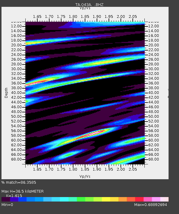
Q43A New Douglas, IL, USA - Earthquake Result Viewer
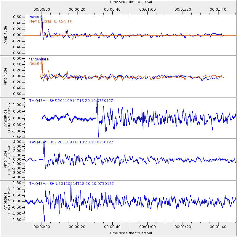
Earthquake location: Near Islands, Aleutian Islands
Earthquake latitude/longitude: 53.1/173.0
Earthquake time(UTC): 2011/09/14 (257) 18:10:09 GMT
Earthquake Depth: 15 km
Earthquake Magnitude: 6.1 MB, 5.7 MS, 6.0 MW, 6.0 MW
Earthquake Catalog/Contributor: WHDF/NEIC
Network: TA USArray Transportable Network (new EarthScope stations)
Station: Q43A New Douglas, IL, USA
Lat/Lon: 38.94 N/89.70 W
Elevation: 202 m
Distance: 63.9 deg
Az: 59.445 deg
Baz: 318.261 deg
Ray Param: 0.059246134
Estimated Moho Depth: 36.5 km
Estimated Crust Vp/Vs: 1.62
Assumed Crust Vp: 6.444 km/s
Estimated Crust Vs: 3.99 km/s
Estimated Crust Poisson's Ratio: 0.19
Radial Match: 86.3585 %
Radial Bump: 400
Transverse Match: 64.16982 %
Transverse Bump: 400
SOD ConfigId: 414626
Insert Time: 2012-01-23 10:59:29.806 +0000
GWidth: 2.5
Max Bumps: 400
Tol: 0.001

Signal To Noise

ChannelStoNSTALTA
TA:Q43A: :BHZ:20110914T18:20:10.075012Z10.9251831.5209207E-61.3921237E-7
TA:Q43A: :BHN:20110914T18:20:10.075012Z4.6412585.769819E-71.2431586E-7
TA:Q43A: :BHE:20110914T18:20:10.075012Z4.63075735.935624E-71.2817826E-7
Arrivals
Ps3.7 SECOND
PpPs14 SECOND
PsPs/PpSs18 SECOND