You are here: Home > Network List > TA - USArray Transportable Network (new EarthScope stations) Stations List
> Station S41A Jillco Farms, Salem, MO, USA > Earthquake Result Viewer
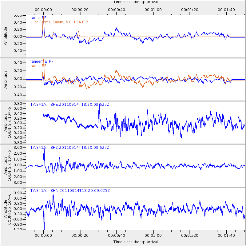
S41A Jillco Farms, Salem, MO, USA - Earthquake Result Viewer
*The percent match for this event was below the threshold and hence no stack was calculated.
| Earthquake location: |
Near Islands, Aleutian Islands |
| Earthquake latitude/longitude: |
53.1/173.0 |
| Earthquake time(UTC): |
2011/09/14 (257) 18:10:09 GMT |
| Earthquake Depth: |
15 km |
| Earthquake Magnitude: |
6.1 MB, 5.7 MS, 6.0 MW, 6.0 MW |
| Earthquake Catalog/Contributor: |
WHDF/NEIC |
|
| Network: |
TA USArray Transportable Network (new EarthScope stations) |
| Station: |
S41A Jillco Farms, Salem, MO, USA |
| Lat/Lon: |
37.59 N/91.75 W |
| Elevation: |
376 m |
|
| Distance: |
63.9 deg |
| Az: |
61.785 deg |
| Baz: |
318.028 deg |
| Ray Param: |
$rayparam |
*The percent match for this event was below the threshold and hence was not used in the summary stack. |
|
| Radial Match: |
64.77361 % |
| Radial Bump: |
400 |
| Transverse Match: |
54.05325 % |
| Transverse Bump: |
400 |
| SOD ConfigId: |
414626 |
| Insert Time: |
2012-01-23 11:00:28.528 +0000 |
| GWidth: |
2.5 |
| Max Bumps: |
400 |
| Tol: |
0.001 |
|
Signal To Noise
| Channel | StoN | STA | LTA |
| TA:S41A: :BHZ:20110914T18:20:09.625Z | 9.0691805 | 1.024237E-6 | 1.12936014E-7 |
| TA:S41A: :BHN:20110914T18:20:09.625Z | 3.4813416 | 4.0243103E-7 | 1.15596535E-7 |
| TA:S41A: :BHE:20110914T18:20:09.625Z | 1.8014282 | 2.9301762E-7 | 1.626585E-7 |
| Arrivals |
| Ps | |
| PpPs | |
| PsPs/PpSs | |


