You are here: Home > Network List > TA - USArray Transportable Network (new EarthScope stations) Stations List
> Station M42A Sheffield, IL, USA > Earthquake Result Viewer
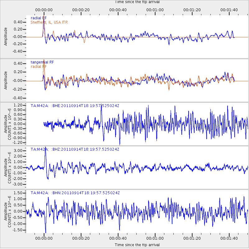
M42A Sheffield, IL, USA - Earthquake Result Viewer
*The percent match for this event was below the threshold and hence no stack was calculated.
| Earthquake location: |
Near Islands, Aleutian Islands |
| Earthquake latitude/longitude: |
53.1/173.0 |
| Earthquake time(UTC): |
2011/09/14 (257) 18:10:09 GMT |
| Earthquake Depth: |
15 km |
| Earthquake Magnitude: |
6.1 MB, 5.7 MS, 6.0 MW, 6.0 MW |
| Earthquake Catalog/Contributor: |
WHDF/NEIC |
|
| Network: |
TA USArray Transportable Network (new EarthScope stations) |
| Station: |
M42A Sheffield, IL, USA |
| Lat/Lon: |
41.45 N/89.76 W |
| Elevation: |
212 m |
|
| Distance: |
62.0 deg |
| Az: |
57.59 deg |
| Baz: |
317.38 deg |
| Ray Param: |
$rayparam |
*The percent match for this event was below the threshold and hence was not used in the summary stack. |
|
| Radial Match: |
72.913284 % |
| Radial Bump: |
400 |
| Transverse Match: |
69.06159 % |
| Transverse Bump: |
400 |
| SOD ConfigId: |
414626 |
| Insert Time: |
2012-01-23 11:01:25.736 +0000 |
| GWidth: |
2.5 |
| Max Bumps: |
400 |
| Tol: |
0.001 |
|
Signal To Noise
| Channel | StoN | STA | LTA |
| TA:M42A: :BHZ:20110914T18:19:57.525024Z | 7.9028234 | 1.3320092E-6 | 1.6854852E-7 |
| TA:M42A: :BHN:20110914T18:19:57.525024Z | 2.7778535 | 5.9849145E-7 | 2.1545105E-7 |
| TA:M42A: :BHE:20110914T18:19:57.525024Z | 2.9536326 | 4.8861705E-7 | 1.654292E-7 |
| Arrivals |
| Ps | |
| PpPs | |
| PsPs/PpSs | |


