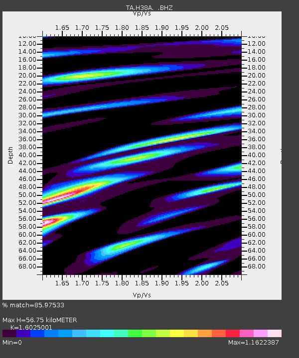
H38A Maiden Rock, WI, USA - Earthquake Result Viewer
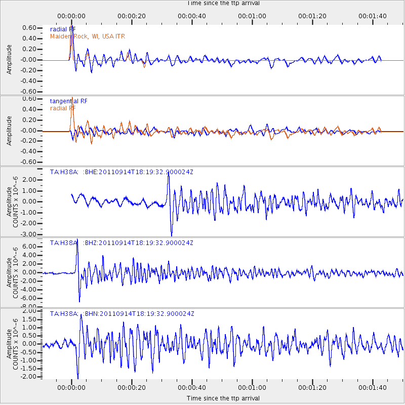
Earthquake location: Near Islands, Aleutian Islands
Earthquake latitude/longitude: 53.1/173.0
Earthquake time(UTC): 2011/09/14 (257) 18:10:09 GMT
Earthquake Depth: 15 km
Earthquake Magnitude: 6.1 MB, 5.7 MS, 6.0 MW, 6.0 MW
Earthquake Catalog/Contributor: WHDF/NEIC
Network: TA USArray Transportable Network (new EarthScope stations)
Station: H38A Maiden Rock, WI, USA
Lat/Lon: 44.68 N/92.28 W
Elevation: 333 m
Distance: 58.4 deg
Az: 56.567 deg
Baz: 315.154 deg
Ray Param: 0.06283757
Estimated Moho Depth: 56.75 km
Estimated Crust Vp/Vs: 1.60
Assumed Crust Vp: 6.571 km/s
Estimated Crust Vs: 4.1 km/s
Estimated Crust Poisson's Ratio: 0.18
Radial Match: 85.97533 %
Radial Bump: 400
Transverse Match: 81.08819 %
Transverse Bump: 400
SOD ConfigId: 414626
Insert Time: 2012-01-23 11:03:19.262 +0000
GWidth: 2.5
Max Bumps: 400
Tol: 0.001

Signal To Noise

ChannelStoNSTALTA
TA:H38A: :BHZ:20110914T18:19:32.900024Z18.7347152.8099917E-61.499885E-7
TA:H38A: :BHN:20110914T18:19:32.900024Z5.07901539.0950346E-71.7907082E-7
TA:H38A: :BHE:20110914T18:19:32.900024Z4.7495951.3259158E-62.7916397E-7
Arrivals
Ps5.5 SECOND
PpPs21 SECOND
PsPs/PpSs27 SECOND