You are here: Home > Network List > TA - USArray Transportable Network (new EarthScope stations) Stations List
> Station N42A Yates City, IL, USA > Earthquake Result Viewer
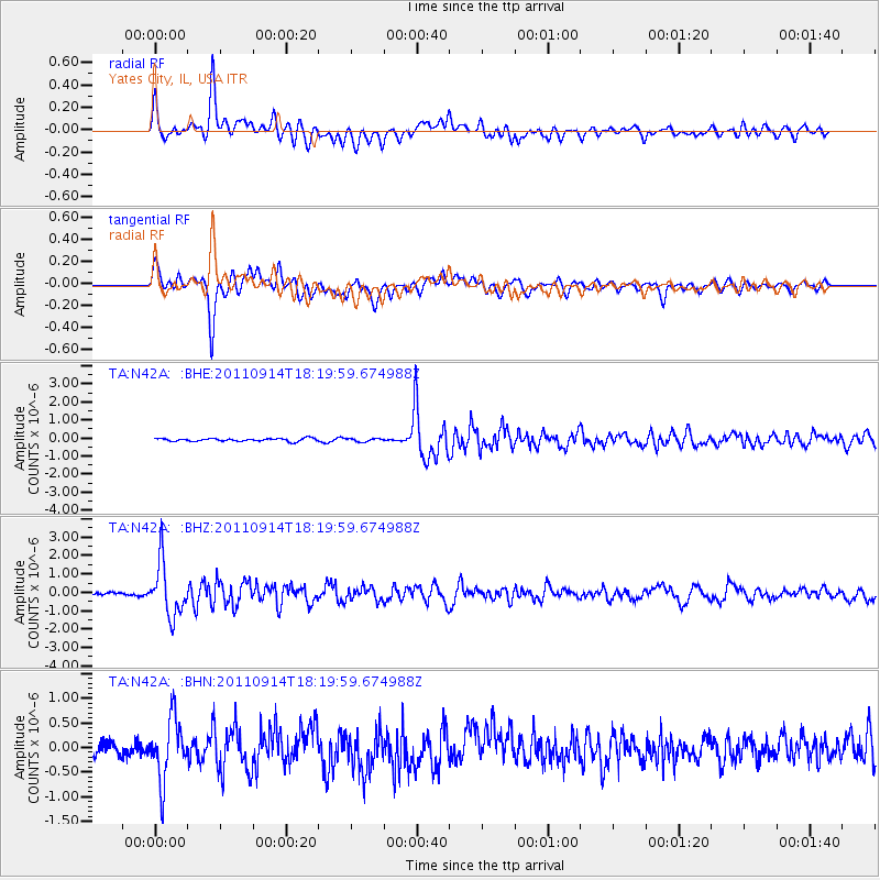
N42A Yates City, IL, USA - Earthquake Result Viewer
*The percent match for this event was below the threshold and hence no stack was calculated.
| Earthquake location: |
Near Islands, Aleutian Islands |
| Earthquake latitude/longitude: |
53.1/173.0 |
| Earthquake time(UTC): |
2011/09/14 (257) 18:10:09 GMT |
| Earthquake Depth: |
15 km |
| Earthquake Magnitude: |
6.1 MB, 5.7 MS, 6.0 MW, 6.0 MW |
| Earthquake Catalog/Contributor: |
WHDF/NEIC |
|
| Network: |
TA USArray Transportable Network (new EarthScope stations) |
| Station: |
N42A Yates City, IL, USA |
| Lat/Lon: |
40.83 N/90.03 W |
| Elevation: |
205 m |
|
| Distance: |
62.4 deg |
| Az: |
58.242 deg |
| Baz: |
317.503 deg |
| Ray Param: |
$rayparam |
*The percent match for this event was below the threshold and hence was not used in the summary stack. |
|
| Radial Match: |
81.57188 % |
| Radial Bump: |
400 |
| Transverse Match: |
82.29435 % |
| Transverse Bump: |
400 |
| SOD ConfigId: |
414626 |
| Insert Time: |
2012-01-23 11:03:48.238 +0000 |
| GWidth: |
2.5 |
| Max Bumps: |
400 |
| Tol: |
0.001 |
|
Signal To Noise
| Channel | StoN | STA | LTA |
| TA:N42A: :BHZ:20110914T18:19:59.674988Z | 10.82457 | 1.4455288E-6 | 1.3354145E-7 |
| TA:N42A: :BHN:20110914T18:19:59.674988Z | 4.4242616 | 6.168061E-7 | 1.3941447E-7 |
| TA:N42A: :BHE:20110914T18:19:59.674988Z | 1.1187302 | 8.857394E-8 | 7.917364E-8 |
| Arrivals |
| Ps | |
| PpPs | |
| PsPs/PpSs | |


