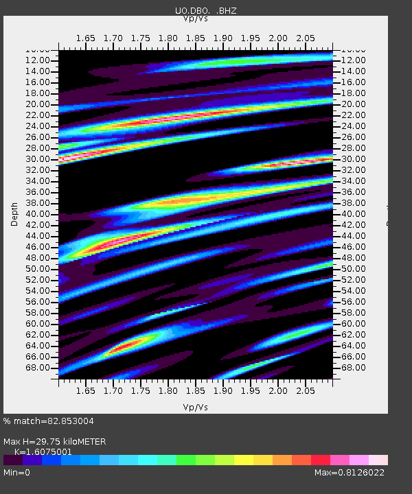
DBO Dodson Butte, OR (UO CREST BB SMO) - Earthquake Result Viewer

Earthquake location: Near Islands, Aleutian Islands
Earthquake latitude/longitude: 53.1/173.0
Earthquake time(UTC): 2011/09/14 (257) 18:10:09 GMT
Earthquake Depth: 15 km
Earthquake Magnitude: 6.1 MB, 5.7 MS, 6.0 MW, 6.0 MW
Earthquake Catalog/Contributor: WHDF/NEIC
Network: UO University of Oregon Regional Network
Station: DBO Dodson Butte, OR (UO CREST BB SMO)
Lat/Lon: 43.12 N/123.24 W
Elevation: 984 m
Distance: 42.4 deg
Az: 76.934 deg
Baz: 306.672 deg
Ray Param: 0.07318485
Estimated Moho Depth: 29.75 km
Estimated Crust Vp/Vs: 1.61
Assumed Crust Vp: 6.522 km/s
Estimated Crust Vs: 4.057 km/s
Estimated Crust Poisson's Ratio: 0.18
Radial Match: 82.853004 %
Radial Bump: 400
Transverse Match: 59.761086 %
Transverse Bump: 400
SOD ConfigId: 414626
Insert Time: 2012-01-23 11:05:21.463 +0000
GWidth: 2.5
Max Bumps: 400
Tol: 0.001

Signal To Noise

ChannelStoNSTALTA
UO:DBO: :BHZ:20110914T18:17:31.88501Z7.162752.263596E-63.160233E-7
UO:DBO: :BHN:20110914T18:17:31.88501Z4.5401689.961375E-72.1940542E-7
UO:DBO: :BHE:20110914T18:17:31.88501Z3.45767288.412138E-72.43289E-7
Arrivals
Ps3.0 SECOND
PpPs11 SECOND
PsPs/PpSs14 SECOND