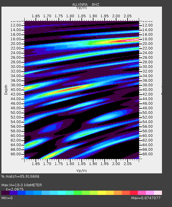
KNRA Kunnunarra, Western Australia - Earthquake Result Viewer

Earthquake location: East Of North Island, N.Z.
Earthquake latitude/longitude: -35.4/-179.0
Earthquake time(UTC): 2011/09/15 (258) 07:53:18 GMT
Earthquake Depth: 10 km
Earthquake Magnitude: 6.0 MB, 6.2 MS, 6.1 MW, 6.0 MW
Earthquake Catalog/Contributor: WHDF/NEIC
Network: AU Australian Seismological Centre
Station: KNRA Kunnunarra, Western Australia
Lat/Lon: 15.68 S/128.76 E
Elevation: 101 m
Distance: 50.4 deg
Az: 279.013 deg
Baz: 123.072 deg
Ray Param: 0.068075955
Estimated Moho Depth: 18.0 km
Estimated Crust Vp/Vs: 2.10
Assumed Crust Vp: 6.397 km/s
Estimated Crust Vs: 3.05 km/s
Estimated Crust Poisson's Ratio: 0.35
Radial Match: 85.918686 %
Radial Bump: 400
Transverse Match: 70.390076 %
Transverse Bump: 400
SOD ConfigId: 414626
Insert Time: 2012-01-23 11:13:22.923 +0000
GWidth: 2.5
Max Bumps: 400
Tol: 0.001

Signal To Noise

ChannelStoNSTALTA
AU:KNRA: :BHZ:20110915T08:01:45.11999Z2.87053258.84923E-73.0827835E-7
AU:KNRA: :BHN:20110915T08:01:45.11999Z1.0331022.4734803E-72.3942266E-7
AU:KNRA: :BHE:20110915T08:01:45.11999Z2.30923153.8295673E-71.6583729E-7
Arrivals
Ps3.2 SECOND
PpPs8.3 SECOND
PsPs/PpSs12 SECOND