You are here: Home > Network List > CI - Caltech Regional Seismic Network Stations List
> Station SLA SLA, Trona, CA, USA > Earthquake Result Viewer
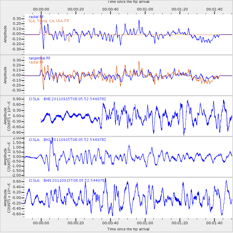
SLA SLA, Trona, CA, USA - Earthquake Result Viewer
*The percent match for this event was below the threshold and hence no stack was calculated.
| Earthquake location: |
East Of North Island, N.Z. |
| Earthquake latitude/longitude: |
-35.4/-179.0 |
| Earthquake time(UTC): |
2011/09/15 (258) 07:53:18 GMT |
| Earthquake Depth: |
10 km |
| Earthquake Magnitude: |
6.0 MB, 6.2 MS, 6.1 MW, 6.0 MW |
| Earthquake Catalog/Contributor: |
WHDF/NEIC |
|
| Network: |
CI Caltech Regional Seismic Network |
| Station: |
SLA SLA, Trona, CA, USA |
| Lat/Lon: |
35.89 N/117.28 W |
| Elevation: |
1174 m |
|
| Distance: |
91.3 deg |
| Az: |
45.684 deg |
| Baz: |
226.068 deg |
| Ray Param: |
$rayparam |
*The percent match for this event was below the threshold and hence was not used in the summary stack. |
|
| Radial Match: |
73.641075 % |
| Radial Bump: |
400 |
| Transverse Match: |
65.31618 % |
| Transverse Bump: |
400 |
| SOD ConfigId: |
414626 |
| Insert Time: |
2012-01-23 11:18:08.114 +0000 |
| GWidth: |
2.5 |
| Max Bumps: |
400 |
| Tol: |
0.001 |
|
Signal To Noise
| Channel | StoN | STA | LTA |
| CI:SLA: :BHZ:20110915T08:05:52.544978Z | 3.8606906 | 5.768056E-7 | 1.4940477E-7 |
| CI:SLA: :BHN:20110915T08:05:52.544978Z | 0.94816166 | 1.7818884E-7 | 1.8793085E-7 |
| CI:SLA: :BHE:20110915T08:05:52.544978Z | 2.0281901 | 2.8294784E-7 | 1.3950755E-7 |
| Arrivals |
| Ps | |
| PpPs | |
| PsPs/PpSs | |


