You are here: Home > Network List > IW - Intermountain West Stations List
> Station PLID Pearl Lake, Idaho, USA > Earthquake Result Viewer
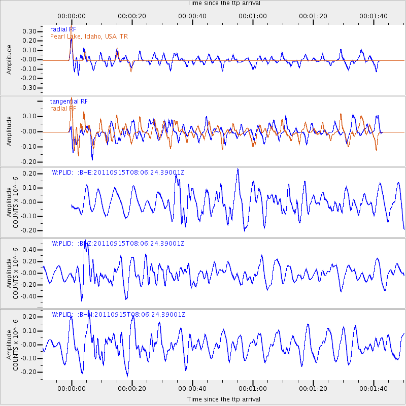
PLID Pearl Lake, Idaho, USA - Earthquake Result Viewer
*The percent match for this event was below the threshold and hence no stack was calculated.
| Earthquake location: |
East Of North Island, N.Z. |
| Earthquake latitude/longitude: |
-35.4/-179.0 |
| Earthquake time(UTC): |
2011/09/15 (258) 07:53:18 GMT |
| Earthquake Depth: |
10 km |
| Earthquake Magnitude: |
6.0 MB, 6.2 MS, 6.1 MW, 6.0 MW |
| Earthquake Catalog/Contributor: |
WHDF/NEIC |
|
| Network: |
IW Intermountain West |
| Station: |
PLID Pearl Lake, Idaho, USA |
| Lat/Lon: |
45.09 N/116.00 W |
| Elevation: |
2164 m |
|
| Distance: |
98.3 deg |
| Az: |
39.648 deg |
| Baz: |
227.406 deg |
| Ray Param: |
$rayparam |
*The percent match for this event was below the threshold and hence was not used in the summary stack. |
|
| Radial Match: |
55.55683 % |
| Radial Bump: |
365 |
| Transverse Match: |
45.56462 % |
| Transverse Bump: |
325 |
| SOD ConfigId: |
414626 |
| Insert Time: |
2012-01-23 11:21:53.130 +0000 |
| GWidth: |
2.5 |
| Max Bumps: |
400 |
| Tol: |
0.001 |
|
Signal To Noise
| Channel | StoN | STA | LTA |
| IW:PLID: :BHZ:20110915T08:06:24.39001Z | 3.2129357 | 2.4531565E-7 | 7.635249E-8 |
| IW:PLID: :BHN:20110915T08:06:24.39001Z | 2.087602 | 1.2588211E-7 | 6.029986E-8 |
| IW:PLID: :BHE:20110915T08:06:24.39001Z | 1.2996584 | 8.248534E-8 | 6.346694E-8 |
| Arrivals |
| Ps | |
| PpPs | |
| PsPs/PpSs | |


