You are here: Home > Network List > TA - USArray Transportable Network (new EarthScope stations) Stations List
> Station L02D Cave Junction, OR, USA > Earthquake Result Viewer
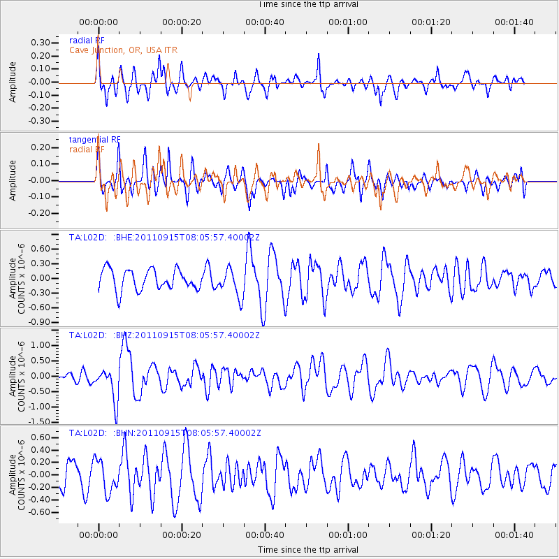
L02D Cave Junction, OR, USA - Earthquake Result Viewer
*The percent match for this event was below the threshold and hence no stack was calculated.
| Earthquake location: |
East Of North Island, N.Z. |
| Earthquake latitude/longitude: |
-35.4/-179.0 |
| Earthquake time(UTC): |
2011/09/15 (258) 07:53:18 GMT |
| Earthquake Depth: |
10 km |
| Earthquake Magnitude: |
6.0 MB, 6.2 MS, 6.1 MW, 6.0 MW |
| Earthquake Catalog/Contributor: |
WHDF/NEIC |
|
| Network: |
TA USArray Transportable Network (new EarthScope stations) |
| Station: |
L02D Cave Junction, OR, USA |
| Lat/Lon: |
42.16 N/123.60 W |
| Elevation: |
458 m |
|
| Distance: |
92.3 deg |
| Az: |
37.792 deg |
| Baz: |
222.345 deg |
| Ray Param: |
$rayparam |
*The percent match for this event was below the threshold and hence was not used in the summary stack. |
|
| Radial Match: |
64.494804 % |
| Radial Bump: |
400 |
| Transverse Match: |
59.30598 % |
| Transverse Bump: |
400 |
| SOD ConfigId: |
414626 |
| Insert Time: |
2012-01-23 11:24:41.812 +0000 |
| GWidth: |
2.5 |
| Max Bumps: |
400 |
| Tol: |
0.001 |
|
Signal To Noise
| Channel | StoN | STA | LTA |
| TA:L02D: :BHZ:20110915T08:05:57.40002Z | 2.1689947 | 5.5676014E-7 | 2.5669044E-7 |
| TA:L02D: :BHN:20110915T08:05:57.40002Z | 1.2113004 | 2.5277652E-7 | 2.0868194E-7 |
| TA:L02D: :BHE:20110915T08:05:57.40002Z | 1.4119794 | 2.9578464E-7 | 2.0948227E-7 |
| Arrivals |
| Ps | |
| PpPs | |
| PsPs/PpSs | |


