You are here: Home > Network List > UW - Pacific Northwest Regional Seismic Network Stations List
> Station WOLL Wollman Farm, Schrag, WA, USA > Earthquake Result Viewer
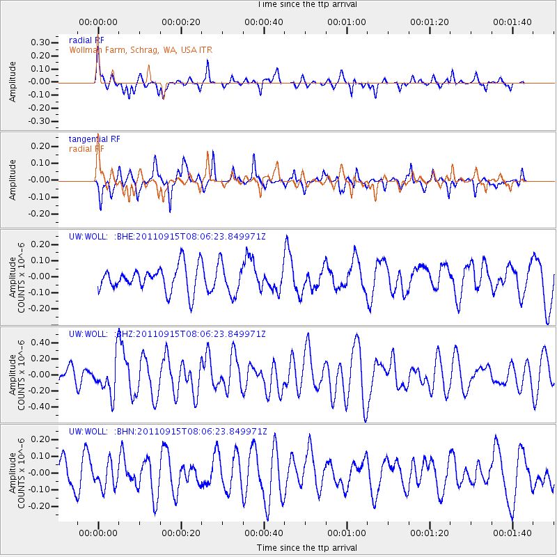
WOLL Wollman Farm, Schrag, WA, USA - Earthquake Result Viewer
*The percent match for this event was below the threshold and hence no stack was calculated.
| Earthquake location: |
East Of North Island, N.Z. |
| Earthquake latitude/longitude: |
-35.4/-179.0 |
| Earthquake time(UTC): |
2011/09/15 (258) 07:53:18 GMT |
| Earthquake Depth: |
10 km |
| Earthquake Magnitude: |
6.0 MB, 6.2 MS, 6.1 MW, 6.0 MW |
| Earthquake Catalog/Contributor: |
WHDF/NEIC |
|
| Network: |
UW Pacific Northwest Regional Seismic Network |
| Station: |
WOLL Wollman Farm, Schrag, WA, USA |
| Lat/Lon: |
47.06 N/118.92 W |
| Elevation: |
385 m |
|
| Distance: |
98.2 deg |
| Az: |
36.791 deg |
| Baz: |
225.718 deg |
| Ray Param: |
$rayparam |
*The percent match for this event was below the threshold and hence was not used in the summary stack. |
|
| Radial Match: |
64.839775 % |
| Radial Bump: |
242 |
| Transverse Match: |
56.189445 % |
| Transverse Bump: |
284 |
| SOD ConfigId: |
414626 |
| Insert Time: |
2012-01-23 11:26:41.681 +0000 |
| GWidth: |
2.5 |
| Max Bumps: |
400 |
| Tol: |
0.001 |
|
Signal To Noise
| Channel | StoN | STA | LTA |
| UW:WOLL: :BHZ:20110915T08:06:23.849971Z | 2.292265 | 2.3771766E-7 | 1.0370427E-7 |
| UW:WOLL: :BHN:20110915T08:06:23.849971Z | 1.003531 | 7.5699E-8 | 7.5432645E-8 |
| UW:WOLL: :BHE:20110915T08:06:23.849971Z | 1.2829225 | 9.809777E-8 | 7.6464296E-8 |
| Arrivals |
| Ps | |
| PpPs | |
| PsPs/PpSs | |


