You are here: Home > Network List > HV - Hawaiian Volcano Observatory Network Stations List
> Station MLOD Mauna Loa, Hawaii Digital > Earthquake Result Viewer
MLOD Mauna Loa, Hawaii Digital - Earthquake Result Viewer

| Earthquake location: |
Solomon Islands |
| Earthquake latitude/longitude: |
-6.6/155.1 |
| Earthquake time(UTC): |
2014/04/11 (101) 07:07:21 GMT |
| Earthquake Depth: |
50 km |
| Earthquake Magnitude: |
7.1 MWW, 7.0 MWB, 7.3 MI |
| Earthquake Catalog/Contributor: |
NEIC PDE/NEIC COMCAT |
|
| Network: |
HV Hawaiian Volcano Observatory Network |
| Station: |
MLOD Mauna Loa, Hawaii Digital |
| Lat/Lon: |
19.49 N/155.39 W |
| Elevation: |
2044 m |
|
| Distance: |
55.2 deg |
| Az: |
60.894 deg |
| Baz: |
246.935 deg |
| Ray Param: |
0.06479633 |
| Estimated Moho Depth: |
20.0 km |
| Estimated Crust Vp/Vs: |
1.62 |
| Assumed Crust Vp: |
5.195 km/s |
| Estimated Crust Vs: |
3.207 km/s |
| Estimated Crust Poisson's Ratio: |
0.19 |
|
| Radial Match: |
81.21963 % |
| Radial Bump: |
305 |
| Transverse Match: |
73.511635 % |
| Transverse Bump: |
369 |
| SOD ConfigId: |
3390531 |
| Insert Time: |
2019-04-11 06:37:29.311 +0000 |
| GWidth: |
2.5 |
| Max Bumps: |
400 |
| Tol: |
0.001 |
|
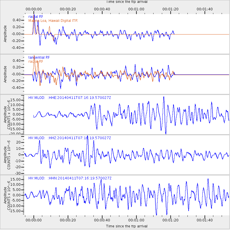
Signal To Noise
| Channel | StoN | STA | LTA |
| HV:MLOD: :HHZ:20140411T07:16:19.570027Z | 5.4328504 | 9.207434E-6 | 1.6947706E-6 |
| HV:MLOD: :HHN:20140411T07:16:19.570027Z | 0.91168374 | 2.0639425E-6 | 2.2638799E-6 |
| HV:MLOD: :HHE:20140411T07:16:19.570027Z | 2.4843583 | 4.027764E-6 | 1.6212492E-6 |
| Arrivals |
| Ps | 2.5 SECOND |
| PpPs | 9.7 SECOND |
| PsPs/PpSs | 12 SECOND |


