You are here: Home > Network List > S - Seismographs in Schools Projects Stations List
> Station AUMTC Mt Clear College/Earth Ed, VIC, Australia > Earthquake Result Viewer
AUMTC Mt Clear College/Earth Ed, VIC, Australia - Earthquake Result Viewer
| Earthquake location: |
Solomon Islands |
| Earthquake latitude/longitude: |
-6.6/155.1 |
| Earthquake time(UTC): |
2014/04/11 (101) 07:07:21 GMT |
| Earthquake Depth: |
50 km |
| Earthquake Magnitude: |
7.1 MWW, 7.0 MWB, 7.3 MI |
| Earthquake Catalog/Contributor: |
NEIC PDE/NEIC COMCAT |
|
| Network: |
S Seismographs in Schools Projects |
| Station: |
AUMTC Mt Clear College/Earth Ed, VIC, Australia |
| Lat/Lon: |
37.61 S/143.88 E |
| Elevation: |
49 m |
|
| Distance: |
32.5 deg |
| Az: |
196.674 deg |
| Baz: |
21.033 deg |
| Ray Param: |
0.07853291 |
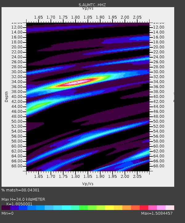
| Estimated Moho Depth: |
34.0 km |
| Estimated Crust Vp/Vs: |
1.81 |
| Assumed Crust Vp: |
6.577 km/s |
| Estimated Crust Vs: |
3.644 km/s |
| Estimated Crust Poisson's Ratio: |
0.28 |
|
| Radial Match: |
88.04381 % |
| Radial Bump: |
239 |
| Transverse Match: |
68.71575 % |
| Transverse Bump: |
400 |
| SOD ConfigId: |
3390531 |
| Insert Time: |
2019-04-11 06:38:44.200 +0000 |
| GWidth: |
2.5 |
| Max Bumps: |
400 |
| Tol: |
0.001 |
|

Signal To Noise
| Channel | StoN | STA | LTA |
| S:AUMTC: :HHZ:20140411T07:13:17.610005Z | 2.3580585 | 1.1394226E-6 | 4.832037E-7 |
| S:AUMTC: :HHN:20140411T07:13:17.610005Z | 2.1972454 | 8.8978004E-7 | 4.0495254E-7 |
| S:AUMTC: :HHE:20140411T07:13:17.610005Z | 0.82168686 | 4.0627134E-7 | 4.944357E-7 |
| Arrivals |
| Ps | 4.5 SECOND |
| PpPs | 13 SECOND |
| PsPs/PpSs | 18 SECOND |


