You are here: Home > Network List > TO - Tectonic Observatory Stations List
> Station CC13 CCSE CC13 > Earthquake Result Viewer
CC13 CCSE CC13 - Earthquake Result Viewer
| Earthquake location: |
Solomon Islands |
| Earthquake latitude/longitude: |
-6.6/155.1 |
| Earthquake time(UTC): |
2014/04/11 (101) 07:07:21 GMT |
| Earthquake Depth: |
50 km |
| Earthquake Magnitude: |
7.1 MWW, 7.0 MWB, 7.3 MI |
| Earthquake Catalog/Contributor: |
NEIC PDE/NEIC COMCAT |
|
| Network: |
TO Tectonic Observatory |
| Station: |
CC13 CCSE CC13 |
| Lat/Lon: |
36.12 N/120.62 W |
| Elevation: |
570 m |
|
| Distance: |
89.3 deg |
| Az: |
53.681 deg |
| Baz: |
261.343 deg |
| Ray Param: |
0.04187652 |
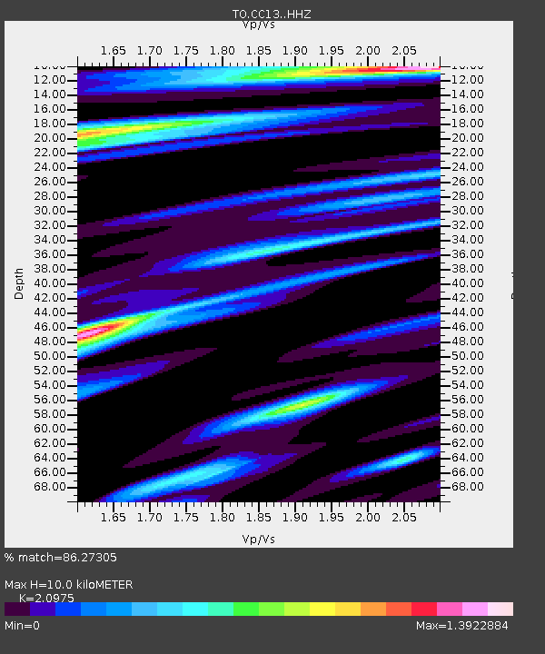
| Estimated Moho Depth: |
10.0 km |
| Estimated Crust Vp/Vs: |
2.10 |
| Assumed Crust Vp: |
6.391 km/s |
| Estimated Crust Vs: |
3.047 km/s |
| Estimated Crust Poisson's Ratio: |
0.35 |
|
| Radial Match: |
86.27305 % |
| Radial Bump: |
385 |
| Transverse Match: |
78.20666 % |
| Transverse Bump: |
378 |
| SOD ConfigId: |
3390531 |
| Insert Time: |
2019-04-11 06:39:04.611 +0000 |
| GWidth: |
2.5 |
| Max Bumps: |
400 |
| Tol: |
0.001 |
|

Signal To Noise
| Channel | StoN | STA | LTA |
| TO:CC13: :HHZ:20140411T07:19:41.570027Z | 26.30312 | 4.6413525E-6 | 1.7645635E-7 |
| TO:CC13: :HHN:20140411T07:19:41.570027Z | 2.3162577 | 5.3517175E-7 | 2.310502E-7 |
| TO:CC13: :HHE:20140411T07:19:41.570027Z | 5.227652 | 1.135747E-6 | 2.1725755E-7 |
| Arrivals |
| Ps | 1.7 SECOND |
| PpPs | 4.8 SECOND |
| PsPs/PpSs | 6.5 SECOND |


