You are here: Home > Network List > TO - Tectonic Observatory Stations List
> Station CC33 CCSE CC33 > Earthquake Result Viewer
CC33 CCSE CC33 - Earthquake Result Viewer
| Earthquake location: |
Solomon Islands |
| Earthquake latitude/longitude: |
-6.6/155.1 |
| Earthquake time(UTC): |
2014/04/11 (101) 07:07:21 GMT |
| Earthquake Depth: |
50 km |
| Earthquake Magnitude: |
7.1 MWW, 7.0 MWB, 7.3 MI |
| Earthquake Catalog/Contributor: |
NEIC PDE/NEIC COMCAT |
|
| Network: |
TO Tectonic Observatory |
| Station: |
CC33 CCSE CC33 |
| Lat/Lon: |
36.34 N/119.12 W |
| Elevation: |
126 m |
|
| Distance: |
90.5 deg |
| Az: |
53.634 deg |
| Baz: |
262.223 deg |
| Ray Param: |
0.041659724 |
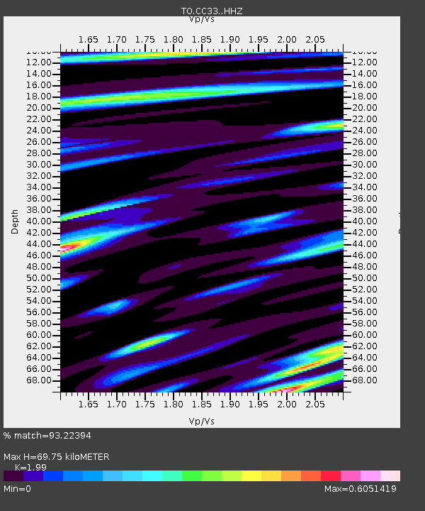
| Estimated Moho Depth: |
69.75 km |
| Estimated Crust Vp/Vs: |
1.99 |
| Assumed Crust Vp: |
6.291 km/s |
| Estimated Crust Vs: |
3.161 km/s |
| Estimated Crust Poisson's Ratio: |
0.33 |
|
| Radial Match: |
93.22394 % |
| Radial Bump: |
400 |
| Transverse Match: |
71.354546 % |
| Transverse Bump: |
400 |
| SOD ConfigId: |
3390531 |
| Insert Time: |
2019-04-11 06:39:18.890 +0000 |
| GWidth: |
2.5 |
| Max Bumps: |
400 |
| Tol: |
0.001 |
|

Signal To Noise
| Channel | StoN | STA | LTA |
| TO:CC33: :HHZ:20140411T07:19:47.260029Z | 49.560806 | 3.9648266E-6 | 7.999924E-8 |
| TO:CC33: :HHN:20140411T07:19:47.260029Z | 1.341585 | 2.4723525E-7 | 1.8428592E-7 |
| TO:CC33: :HHE:20140411T07:19:47.260029Z | 9.321941 | 1.6580917E-6 | 1.778698E-7 |
| Arrivals |
| Ps | 11 SECOND |
| PpPs | 33 SECOND |
| PsPs/PpSs | 44 SECOND |


