You are here: Home > Network List > TO - Tectonic Observatory Stations List
> Station CC37 CCSE CC37 > Earthquake Result Viewer
CC37 CCSE CC37 - Earthquake Result Viewer
| Earthquake location: |
Solomon Islands |
| Earthquake latitude/longitude: |
-6.6/155.1 |
| Earthquake time(UTC): |
2014/04/11 (101) 07:07:21 GMT |
| Earthquake Depth: |
50 km |
| Earthquake Magnitude: |
7.1 MWW, 7.0 MWB, 7.3 MI |
| Earthquake Catalog/Contributor: |
NEIC PDE/NEIC COMCAT |
|
| Network: |
TO Tectonic Observatory |
| Station: |
CC37 CCSE CC37 |
| Lat/Lon: |
36.39 N/118.90 W |
| Elevation: |
654 m |
|
| Distance: |
90.7 deg |
| Az: |
53.615 deg |
| Baz: |
262.354 deg |
| Ray Param: |
0.041646592 |
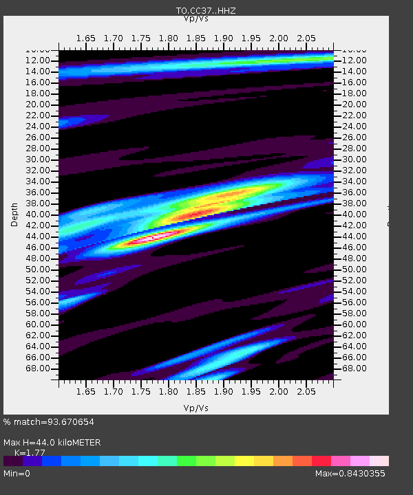
| Estimated Moho Depth: |
44.0 km |
| Estimated Crust Vp/Vs: |
1.77 |
| Assumed Crust Vp: |
6.291 km/s |
| Estimated Crust Vs: |
3.554 km/s |
| Estimated Crust Poisson's Ratio: |
0.27 |
|
| Radial Match: |
93.670654 % |
| Radial Bump: |
347 |
| Transverse Match: |
93.67064 % |
| Transverse Bump: |
347 |
| SOD ConfigId: |
3390531 |
| Insert Time: |
2019-04-11 06:39:21.258 +0000 |
| GWidth: |
2.5 |
| Max Bumps: |
400 |
| Tol: |
0.001 |
|

Signal To Noise
| Channel | StoN | STA | LTA |
| TO:CC37: :HHZ:20140411T07:19:48.110005Z | 29.808496 | 3.4030534E-6 | 1.14163875E-7 |
| $trig.getChannelId() | $trig.getValue() | $trig.getSTA() | $trig.getLTA() |
| TO:CC37: :HHE:20140411T07:19:48.110005Z | 10.759738 | 1.5903686E-6 | 1.4780737E-7 |
| Arrivals |
| Ps | 5.5 SECOND |
| PpPs | 19 SECOND |
| PsPs/PpSs | 24 SECOND |


