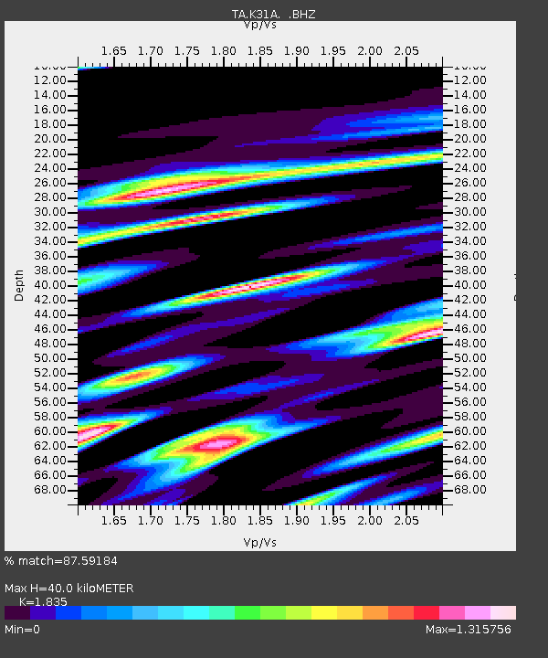
K31A O'Neill, NE, USA - Earthquake Result Viewer
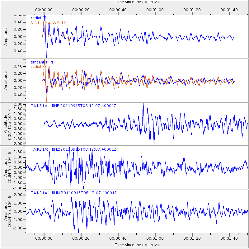
Earthquake location: Near East Coast Of Honshu, Japan
Earthquake latitude/longitude: 36.3/141.3
Earthquake time(UTC): 2011/09/15 (258) 08:00:09 GMT
Earthquake Depth: 28 km
Earthquake Magnitude: 5.8 MB, 6.0 MS, 6.2 MW, 6.1 MW
Earthquake Catalog/Contributor: WHDF/NEIC
Network: TA USArray Transportable Network (new EarthScope stations)
Station: K31A O'Neill, NE, USA
Lat/Lon: 42.62 N/98.75 W
Elevation: 580 m
Distance: 84.3 deg
Az: 40.017 deg
Baz: 315.239 deg
Ray Param: 0.04556896
Estimated Moho Depth: 40.0 km
Estimated Crust Vp/Vs: 1.84
Assumed Crust Vp: 6.53 km/s
Estimated Crust Vs: 3.559 km/s
Estimated Crust Poisson's Ratio: 0.29
Radial Match: 87.59184 %
Radial Bump: 400
Transverse Match: 81.64203 %
Transverse Bump: 400
SOD ConfigId: 414626
Insert Time: 2012-01-23 11:47:59.589 +0000
GWidth: 2.5
Max Bumps: 400
Tol: 0.001

Signal To Noise

ChannelStoNSTALTA
TA:K31A: :BHZ:20110915T08:12:07.40001Z4.0112736.033641E-71.5041711E-7
TA:K31A: :BHN:20110915T08:12:07.40001Z2.69624975.4448924E-72.019432E-7
TA:K31A: :BHE:20110915T08:12:07.40001Z1.37970822.6523466E-71.9223968E-7
Arrivals
Ps5.2 SECOND
PpPs17 SECOND
PsPs/PpSs22 SECOND