You are here: Home > Network List > TA - USArray Transportable Network (new EarthScope stations) Stations List
> Station G32A Webster, SD, USA > Earthquake Result Viewer
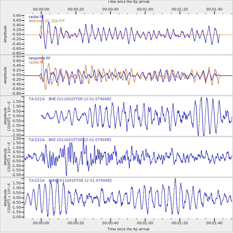
G32A Webster, SD, USA - Earthquake Result Viewer
*The percent match for this event was below the threshold and hence no stack was calculated.
| Earthquake location: |
Near East Coast Of Honshu, Japan |
| Earthquake latitude/longitude: |
36.3/141.3 |
| Earthquake time(UTC): |
2011/09/15 (258) 08:00:09 GMT |
| Earthquake Depth: |
28 km |
| Earthquake Magnitude: |
5.8 MB, 6.0 MS, 6.2 MW, 6.1 MW |
| Earthquake Catalog/Contributor: |
WHDF/NEIC |
|
| Network: |
TA USArray Transportable Network (new EarthScope stations) |
| Station: |
G32A Webster, SD, USA |
| Lat/Lon: |
45.26 N/97.50 W |
| Elevation: |
566 m |
|
| Distance: |
83.0 deg |
| Az: |
37.511 deg |
| Baz: |
315.83 deg |
| Ray Param: |
$rayparam |
*The percent match for this event was below the threshold and hence was not used in the summary stack. |
|
| Radial Match: |
60.74357 % |
| Radial Bump: |
386 |
| Transverse Match: |
48.5572 % |
| Transverse Bump: |
374 |
| SOD ConfigId: |
414626 |
| Insert Time: |
2012-01-23 11:49:28.542 +0000 |
| GWidth: |
2.5 |
| Max Bumps: |
400 |
| Tol: |
0.001 |
|
Signal To Noise
| Channel | StoN | STA | LTA |
| TA:G32A: :BHZ:20110915T08:12:01.074998Z | 3.3437376 | 6.0472064E-7 | 1.8085169E-7 |
| TA:G32A: :BHN:20110915T08:12:01.074998Z | 2.172305 | 1.134866E-6 | 5.224248E-7 |
| TA:G32A: :BHE:20110915T08:12:01.074998Z | 2.1525373 | 7.8863326E-7 | 3.663738E-7 |
| Arrivals |
| Ps | |
| PpPs | |
| PsPs/PpSs | |


