You are here: Home > Network List > TA - USArray Transportable Network (new EarthScope stations) Stations List
> Station C35A Jirik Farms, Max, MN, USA > Earthquake Result Viewer
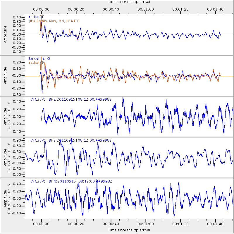
C35A Jirik Farms, Max, MN, USA - Earthquake Result Viewer
*The percent match for this event was below the threshold and hence no stack was calculated.
| Earthquake location: |
Near East Coast Of Honshu, Japan |
| Earthquake latitude/longitude: |
36.3/141.3 |
| Earthquake time(UTC): |
2011/09/15 (258) 08:00:09 GMT |
| Earthquake Depth: |
28 km |
| Earthquake Magnitude: |
5.8 MB, 6.0 MS, 6.2 MW, 6.1 MW |
| Earthquake Catalog/Contributor: |
WHDF/NEIC |
|
| Network: |
TA USArray Transportable Network (new EarthScope stations) |
| Station: |
C35A Jirik Farms, Max, MN, USA |
| Lat/Lon: |
47.70 N/93.98 W |
| Elevation: |
426 m |
|
| Distance: |
82.9 deg |
| Az: |
34.036 deg |
| Baz: |
317.952 deg |
| Ray Param: |
$rayparam |
*The percent match for this event was below the threshold and hence was not used in the summary stack. |
|
| Radial Match: |
59.64021 % |
| Radial Bump: |
400 |
| Transverse Match: |
57.259434 % |
| Transverse Bump: |
400 |
| SOD ConfigId: |
414626 |
| Insert Time: |
2012-01-23 11:50:00.163 +0000 |
| GWidth: |
2.5 |
| Max Bumps: |
400 |
| Tol: |
0.001 |
|
Signal To Noise
| Channel | StoN | STA | LTA |
| TA:C35A: :BHZ:20110915T08:12:00.449998Z | 2.5863533 | 3.7921106E-7 | 1.4661998E-7 |
| TA:C35A: :BHN:20110915T08:12:00.449998Z | 1.5233318 | 1.4419051E-7 | 9.4654695E-8 |
| TA:C35A: :BHE:20110915T08:12:00.449998Z | 1.531327 | 1.3542946E-7 | 8.843928E-8 |
| Arrivals |
| Ps | |
| PpPs | |
| PsPs/PpSs | |


