You are here: Home > Network List > TA - USArray Transportable Network (new EarthScope stations) Stations List
> Station B35A Bob, Littlefork, MN, USA > Earthquake Result Viewer
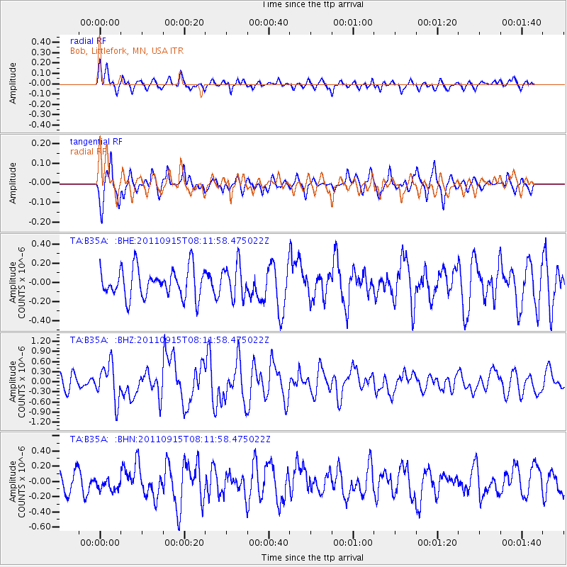
B35A Bob, Littlefork, MN, USA - Earthquake Result Viewer
*The percent match for this event was below the threshold and hence no stack was calculated.
| Earthquake location: |
Near East Coast Of Honshu, Japan |
| Earthquake latitude/longitude: |
36.3/141.3 |
| Earthquake time(UTC): |
2011/09/15 (258) 08:00:09 GMT |
| Earthquake Depth: |
28 km |
| Earthquake Magnitude: |
5.8 MB, 6.0 MS, 6.2 MW, 6.1 MW |
| Earthquake Catalog/Contributor: |
WHDF/NEIC |
|
| Network: |
TA USArray Transportable Network (new EarthScope stations) |
| Station: |
B35A Bob, Littlefork, MN, USA |
| Lat/Lon: |
48.36 N/93.73 W |
| Elevation: |
358 m |
|
| Distance: |
82.5 deg |
| Az: |
33.465 deg |
| Baz: |
318.065 deg |
| Ray Param: |
$rayparam |
*The percent match for this event was below the threshold and hence was not used in the summary stack. |
|
| Radial Match: |
66.613754 % |
| Radial Bump: |
400 |
| Transverse Match: |
65.44601 % |
| Transverse Bump: |
374 |
| SOD ConfigId: |
414626 |
| Insert Time: |
2012-01-23 11:52:00.517 +0000 |
| GWidth: |
2.5 |
| Max Bumps: |
400 |
| Tol: |
0.001 |
|
Signal To Noise
| Channel | StoN | STA | LTA |
| TA:B35A: :BHZ:20110915T08:11:58.475022Z | 2.203728 | 5.551136E-7 | 2.5189752E-7 |
| TA:B35A: :BHN:20110915T08:11:58.475022Z | 0.50514114 | 7.968278E-8 | 1.5774359E-7 |
| TA:B35A: :BHE:20110915T08:11:58.475022Z | 1.1669322 | 1.7628078E-7 | 1.5106342E-7 |
| Arrivals |
| Ps | |
| PpPs | |
| PsPs/PpSs | |


