You are here: Home > Network List > YT07 - POLENET Stations List
> Station LONW LONW > Earthquake Result Viewer
LONW LONW - Earthquake Result Viewer
| Earthquake location: |
Solomon Islands |
| Earthquake latitude/longitude: |
-6.6/155.1 |
| Earthquake time(UTC): |
2014/04/11 (101) 07:07:21 GMT |
| Earthquake Depth: |
50 km |
| Earthquake Magnitude: |
7.1 MWW, 7.0 MWB, 7.3 MI |
| Earthquake Catalog/Contributor: |
NEIC PDE/NEIC COMCAT |
|
| Network: |
YT POLENET |
| Station: |
LONW LONW |
| Lat/Lon: |
81.35 S/152.74 E |
| Elevation: |
1548 m |
|
| Distance: |
74.7 deg |
| Az: |
180.366 deg |
| Baz: |
2.398 deg |
| Ray Param: |
0.052052286 |
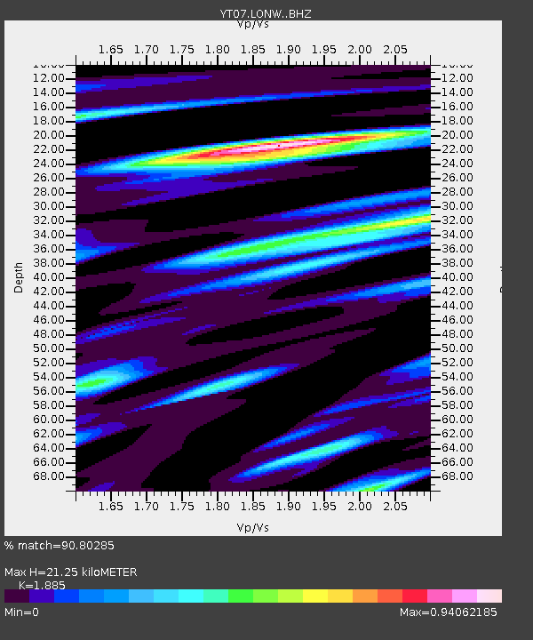
| Estimated Moho Depth: |
21.25 km |
| Estimated Crust Vp/Vs: |
1.88 |
| Assumed Crust Vp: |
6.306 km/s |
| Estimated Crust Vs: |
3.345 km/s |
| Estimated Crust Poisson's Ratio: |
0.30 |
|
| Radial Match: |
90.80285 % |
| Radial Bump: |
400 |
| Transverse Match: |
73.89595 % |
| Transverse Bump: |
400 |
| SOD ConfigId: |
3390531 |
| Insert Time: |
2019-04-11 06:39:58.607 +0000 |
| GWidth: |
2.5 |
| Max Bumps: |
400 |
| Tol: |
0.001 |
|

Signal To Noise
| Channel | StoN | STA | LTA |
| YT:LONW: :BHZ:20140411T07:18:25.573994Z | 16.98631 | 4.937403E-6 | 2.9066956E-7 |
| YT:LONW: :BHN:20140411T07:18:25.573994Z | 5.1422954 | 2.7411022E-6 | 5.330503E-7 |
| YT:LONW: :BHE:20140411T07:18:25.573994Z | 1.2657328 | 1.1620374E-6 | 9.180749E-7 |
| Arrivals |
| Ps | 3.1 SECOND |
| PpPs | 9.4 SECOND |
| PsPs/PpSs | 13 SECOND |


