You are here: Home > Network List > YT07 - POLENET Stations List
> Station MECK MECK > Earthquake Result Viewer
MECK MECK - Earthquake Result Viewer
| Earthquake location: |
Solomon Islands |
| Earthquake latitude/longitude: |
-6.6/155.1 |
| Earthquake time(UTC): |
2014/04/11 (101) 07:07:21 GMT |
| Earthquake Depth: |
50 km |
| Earthquake Magnitude: |
7.1 MWW, 7.0 MWB, 7.3 MI |
| Earthquake Catalog/Contributor: |
NEIC PDE/NEIC COMCAT |
|
| Network: |
YT POLENET |
| Station: |
MECK MECK |
| Lat/Lon: |
75.28 S/72.18 W |
| Elevation: |
1086 m |
|
| Distance: |
93.5 deg |
| Az: |
169.158 deg |
| Baz: |
226.959 deg |
| Ray Param: |
0.04122058 |
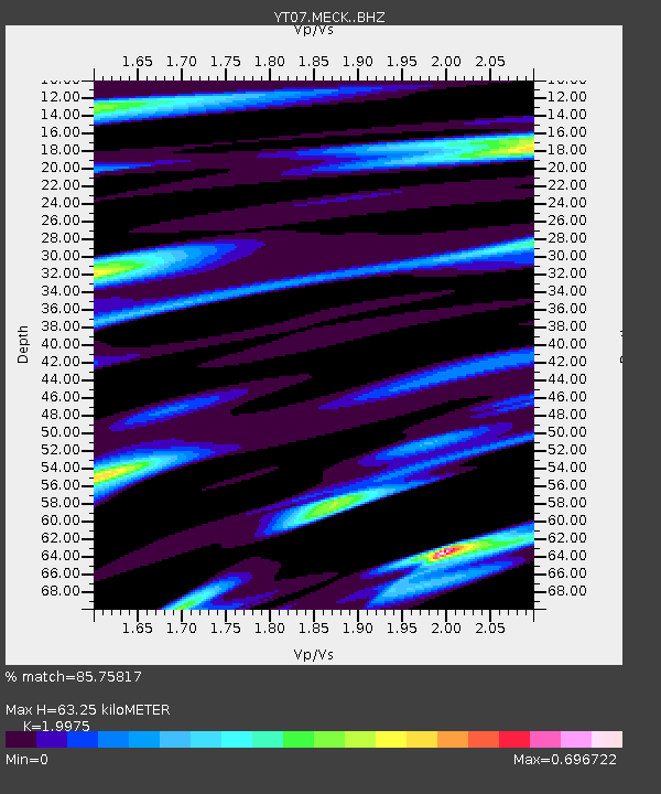
| Estimated Moho Depth: |
63.25 km |
| Estimated Crust Vp/Vs: |
2.00 |
| Assumed Crust Vp: |
6.338 km/s |
| Estimated Crust Vs: |
3.173 km/s |
| Estimated Crust Poisson's Ratio: |
0.33 |
|
| Radial Match: |
85.75817 % |
| Radial Bump: |
373 |
| Transverse Match: |
79.39713 % |
| Transverse Bump: |
400 |
| SOD ConfigId: |
3390531 |
| Insert Time: |
2019-04-11 06:39:58.998 +0000 |
| GWidth: |
2.5 |
| Max Bumps: |
400 |
| Tol: |
0.001 |
|

Signal To Noise
| Channel | StoN | STA | LTA |
| YT:MECK: :BHZ:20140411T07:20:01.175007Z | 6.870615 | 3.6555095E-6 | 5.320498E-7 |
| YT:MECK: :BHN:20140411T07:20:01.175007Z | 3.2346256 | 1.5893502E-6 | 4.913552E-7 |
| YT:MECK: :BHE:20140411T07:20:01.175007Z | 2.6004443 | 7.5476936E-7 | 2.902463E-7 |
| Arrivals |
| Ps | 10 SECOND |
| PpPs | 29 SECOND |
| PsPs/PpSs | 40 SECOND |


