You are here: Home > Network List > TA - USArray Transportable Network (new EarthScope stations) Stations List
> Station N59A State Game Land 141, Hazleton, PA, USA > Earthquake Result Viewer
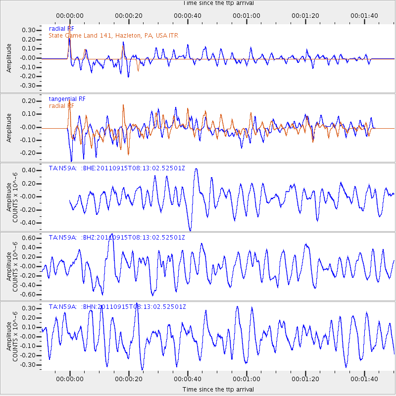
N59A State Game Land 141, Hazleton, PA, USA - Earthquake Result Viewer
*The percent match for this event was below the threshold and hence no stack was calculated.
| Earthquake location: |
Near East Coast Of Honshu, Japan |
| Earthquake latitude/longitude: |
36.3/141.3 |
| Earthquake time(UTC): |
2011/09/15 (258) 08:00:09 GMT |
| Earthquake Depth: |
28 km |
| Earthquake Magnitude: |
5.8 MB, 6.0 MS, 6.2 MW, 6.1 MW |
| Earthquake Catalog/Contributor: |
WHDF/NEIC |
|
| Network: |
TA USArray Transportable Network (new EarthScope stations) |
| Station: |
N59A State Game Land 141, Hazleton, PA, USA |
| Lat/Lon: |
40.92 N/75.77 W |
| Elevation: |
508 m |
|
| Distance: |
96.0 deg |
| Az: |
27.37 deg |
| Baz: |
330.638 deg |
| Ray Param: |
$rayparam |
*The percent match for this event was below the threshold and hence was not used in the summary stack. |
|
| Radial Match: |
43.334244 % |
| Radial Bump: |
400 |
| Transverse Match: |
59.85201 % |
| Transverse Bump: |
400 |
| SOD ConfigId: |
414626 |
| Insert Time: |
2012-01-23 11:52:47.623 +0000 |
| GWidth: |
2.5 |
| Max Bumps: |
400 |
| Tol: |
0.001 |
|
Signal To Noise
| Channel | StoN | STA | LTA |
| TA:N59A: :BHZ:20110915T08:13:02.52501Z | 1.1390136 | 2.0040643E-7 | 1.7594735E-7 |
| TA:N59A: :BHN:20110915T08:13:02.52501Z | 0.5572028 | 6.646298E-8 | 1.1927969E-7 |
| TA:N59A: :BHE:20110915T08:13:02.52501Z | 1.629888 | 1.8026418E-7 | 1.1059912E-7 |
| Arrivals |
| Ps | |
| PpPs | |
| PsPs/PpSs | |


