You are here: Home > Network List > ZJ12 - Transantarctic Mountains Northern Network Stations List
> Station GRAW East Antarctica > Earthquake Result Viewer
GRAW East Antarctica - Earthquake Result Viewer
| Earthquake location: |
Solomon Islands |
| Earthquake latitude/longitude: |
-6.6/155.1 |
| Earthquake time(UTC): |
2014/04/11 (101) 07:07:21 GMT |
| Earthquake Depth: |
50 km |
| Earthquake Magnitude: |
7.1 MWW, 7.0 MWB, 7.3 MI |
| Earthquake Catalog/Contributor: |
NEIC PDE/NEIC COMCAT |
|
| Network: |
ZJ Transantarctic Mountains Northern Network |
| Station: |
GRAW East Antarctica |
| Lat/Lon: |
74.00 S/154.99 E |
| Elevation: |
2205 m |
|
| Distance: |
67.3 deg |
| Az: |
180.023 deg |
| Baz: |
0.081 deg |
| Ray Param: |
0.056930766 |
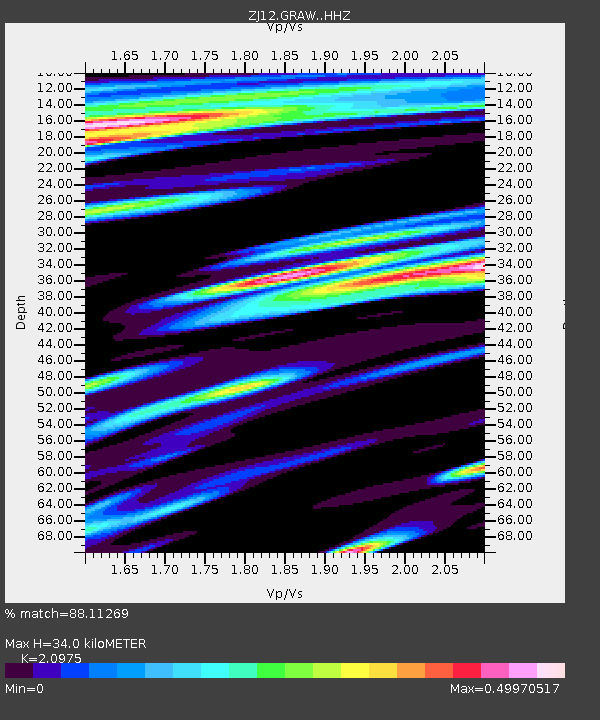
| Estimated Moho Depth: |
34.0 km |
| Estimated Crust Vp/Vs: |
2.10 |
| Assumed Crust Vp: |
6.168 km/s |
| Estimated Crust Vs: |
2.941 km/s |
| Estimated Crust Poisson's Ratio: |
0.35 |
|
| Radial Match: |
88.11269 % |
| Radial Bump: |
374 |
| Transverse Match: |
85.26761 % |
| Transverse Bump: |
400 |
| SOD ConfigId: |
3390531 |
| Insert Time: |
2019-04-11 06:40:16.837 +0000 |
| GWidth: |
2.5 |
| Max Bumps: |
400 |
| Tol: |
0.001 |
|

Signal To Noise
| Channel | StoN | STA | LTA |
| ZJ:GRAW: :HHZ:20140411T07:17:40.949971Z | 22.114218 | 6.1715577E-6 | 2.7907646E-7 |
| ZJ:GRAW: :HHN:20140411T07:17:40.949971Z | 10.747808 | 2.2412628E-6 | 2.0853207E-7 |
| ZJ:GRAW: :HHE:20140411T07:17:40.949971Z | 3.3163903 | 1.3116234E-6 | 3.954973E-7 |
| Arrivals |
| Ps | 6.2 SECOND |
| PpPs | 17 SECOND |
| PsPs/PpSs | 23 SECOND |


