You are here: Home > Network List > TA - USArray Transportable Network (new EarthScope stations) Stations List
> Station T41A Mountain View, MO, USA > Earthquake Result Viewer
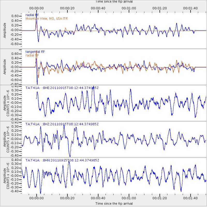
T41A Mountain View, MO, USA - Earthquake Result Viewer
*The percent match for this event was below the threshold and hence no stack was calculated.
| Earthquake location: |
Near East Coast Of Honshu, Japan |
| Earthquake latitude/longitude: |
36.3/141.3 |
| Earthquake time(UTC): |
2011/09/15 (258) 08:00:09 GMT |
| Earthquake Depth: |
28 km |
| Earthquake Magnitude: |
5.8 MB, 6.0 MS, 6.2 MW, 6.1 MW |
| Earthquake Catalog/Contributor: |
WHDF/NEIC |
|
| Network: |
TA USArray Transportable Network (new EarthScope stations) |
| Station: |
T41A Mountain View, MO, USA |
| Lat/Lon: |
37.04 N/91.76 W |
| Elevation: |
366 m |
|
| Distance: |
92.0 deg |
| Az: |
39.81 deg |
| Baz: |
319.701 deg |
| Ray Param: |
$rayparam |
*The percent match for this event was below the threshold and hence was not used in the summary stack. |
|
| Radial Match: |
51.631485 % |
| Radial Bump: |
400 |
| Transverse Match: |
53.840195 % |
| Transverse Bump: |
400 |
| SOD ConfigId: |
414626 |
| Insert Time: |
2012-01-23 11:55:38.345 +0000 |
| GWidth: |
2.5 |
| Max Bumps: |
400 |
| Tol: |
0.001 |
|
Signal To Noise
| Channel | StoN | STA | LTA |
| TA:T41A: :BHZ:20110915T08:12:44.374985Z | 1.3119179 | 1.4023432E-7 | 1.0689261E-7 |
| TA:T41A: :BHN:20110915T08:12:44.374985Z | 1.5633833 | 2.2632638E-7 | 1.4476704E-7 |
| TA:T41A: :BHE:20110915T08:12:44.374985Z | 1.4033375 | 1.822849E-7 | 1.2989385E-7 |
| Arrivals |
| Ps | |
| PpPs | |
| PsPs/PpSs | |


