You are here: Home > Network List > ZJ12 - Transantarctic Mountains Northern Network Stations List
> Station APRL East Antarctica > Earthquake Result Viewer
APRL East Antarctica - Earthquake Result Viewer
| Earthquake location: |
Solomon Islands |
| Earthquake latitude/longitude: |
-6.6/155.1 |
| Earthquake time(UTC): |
2014/04/11 (101) 07:07:21 GMT |
| Earthquake Depth: |
50 km |
| Earthquake Magnitude: |
7.1 MWW, 7.0 MWB, 7.3 MI |
| Earthquake Catalog/Contributor: |
NEIC PDE/NEIC COMCAT |
|
| Network: |
ZJ Transantarctic Mountains Northern Network |
| Station: |
APRL East Antarctica |
| Lat/Lon: |
73.19 S/158.70 E |
| Elevation: |
2258 m |
|
| Distance: |
66.5 deg |
| Az: |
178.847 deg |
| Baz: |
356.058 deg |
| Ray Param: |
0.057441413 |
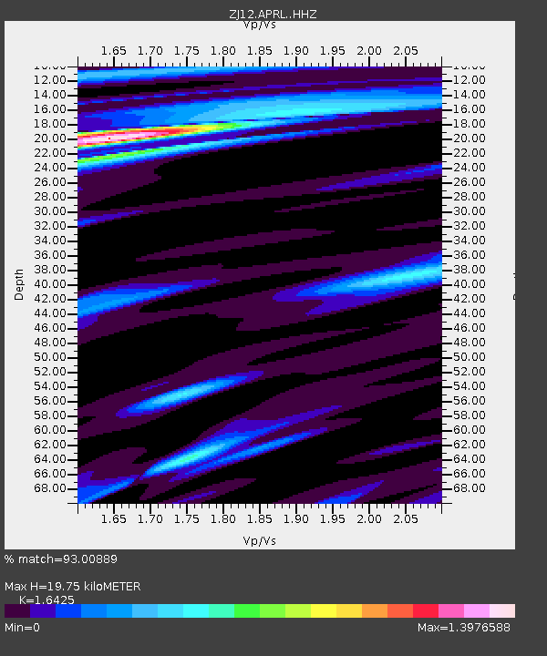
| Estimated Moho Depth: |
19.75 km |
| Estimated Crust Vp/Vs: |
1.64 |
| Assumed Crust Vp: |
6.306 km/s |
| Estimated Crust Vs: |
3.839 km/s |
| Estimated Crust Poisson's Ratio: |
0.21 |
|
| Radial Match: |
93.00889 % |
| Radial Bump: |
400 |
| Transverse Match: |
89.06868 % |
| Transverse Bump: |
400 |
| SOD ConfigId: |
3390531 |
| Insert Time: |
2019-04-11 06:40:17.056 +0000 |
| GWidth: |
2.5 |
| Max Bumps: |
400 |
| Tol: |
0.001 |
|

Signal To Noise
| Channel | StoN | STA | LTA |
| ZJ:APRL: :HHZ:20140411T07:17:36.029011Z | 25.443714 | 6.56991E-6 | 2.5821348E-7 |
| ZJ:APRL: :HHN:20140411T07:17:36.029011Z | 6.568818 | 2.3681798E-6 | 3.605184E-7 |
| ZJ:APRL: :HHE:20140411T07:17:36.029011Z | 1.8100257 | 7.188239E-7 | 3.9713464E-7 |
| Arrivals |
| Ps | 2.1 SECOND |
| PpPs | 7.9 SECOND |
| PsPs/PpSs | 10 SECOND |


