You are here: Home > Network List > TA - USArray Transportable Network (new EarthScope stations) Stations List
> Station I41A Arkdale, WI, USA > Earthquake Result Viewer
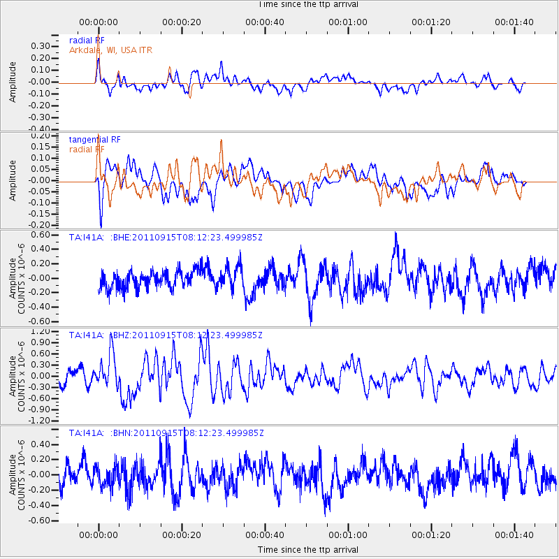
I41A Arkdale, WI, USA - Earthquake Result Viewer
*The percent match for this event was below the threshold and hence no stack was calculated.
| Earthquake location: |
Near East Coast Of Honshu, Japan |
| Earthquake latitude/longitude: |
36.3/141.3 |
| Earthquake time(UTC): |
2011/09/15 (258) 08:00:09 GMT |
| Earthquake Depth: |
28 km |
| Earthquake Magnitude: |
5.8 MB, 6.0 MS, 6.2 MW, 6.1 MW |
| Earthquake Catalog/Contributor: |
WHDF/NEIC |
|
| Network: |
TA USArray Transportable Network (new EarthScope stations) |
| Station: |
I41A Arkdale, WI, USA |
| Lat/Lon: |
44.06 N/89.87 W |
| Elevation: |
289 m |
|
| Distance: |
87.5 deg |
| Az: |
34.225 deg |
| Baz: |
320.908 deg |
| Ray Param: |
$rayparam |
*The percent match for this event was below the threshold and hence was not used in the summary stack. |
|
| Radial Match: |
60.704746 % |
| Radial Bump: |
400 |
| Transverse Match: |
56.660793 % |
| Transverse Bump: |
400 |
| SOD ConfigId: |
414626 |
| Insert Time: |
2012-01-23 11:57:08.118 +0000 |
| GWidth: |
2.5 |
| Max Bumps: |
400 |
| Tol: |
0.001 |
|
Signal To Noise
| Channel | StoN | STA | LTA |
| TA:I41A: :BHZ:20110915T08:12:23.499985Z | 3.3047 | 4.7443606E-7 | 1.4356404E-7 |
| TA:I41A: :BHN:20110915T08:12:23.499985Z | 1.1751529 | 1.3114935E-7 | 1.1160195E-7 |
| TA:I41A: :BHE:20110915T08:12:23.499985Z | 1.3165759 | 1.5648479E-7 | 1.1885741E-7 |
| Arrivals |
| Ps | |
| PpPs | |
| PsPs/PpSs | |


