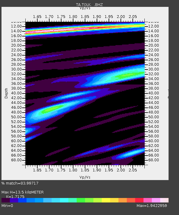
TOLK Tollok Lake Research Station, AK, USA - Earthquake Result Viewer

Earthquake location: Near East Coast Of Honshu, Japan
Earthquake latitude/longitude: 36.3/141.3
Earthquake time(UTC): 2011/09/15 (258) 08:00:09 GMT
Earthquake Depth: 28 km
Earthquake Magnitude: 5.8 MB, 6.0 MS, 6.2 MW, 6.1 MW
Earthquake Catalog/Contributor: WHDF/NEIC
Network: TA USArray Transportable Network (new EarthScope stations)
Station: TOLK Tollok Lake Research Station, AK, USA
Lat/Lon: 68.64 N/149.57 W
Elevation: 760 m
Distance: 49.2 deg
Az: 26.881 deg
Baz: 266.006 deg
Ray Param: 0.06881022
Estimated Moho Depth: 13.5 km
Estimated Crust Vp/Vs: 1.72
Assumed Crust Vp: 6.316 km/s
Estimated Crust Vs: 3.678 km/s
Estimated Crust Poisson's Ratio: 0.24
Radial Match: 83.99717 %
Radial Bump: 400
Transverse Match: 78.75185 %
Transverse Bump: 400
SOD ConfigId: 414626
Insert Time: 2012-01-23 11:58:01.588 +0000
GWidth: 2.5
Max Bumps: 400
Tol: 0.001

Signal To Noise

ChannelStoNSTALTA
TA:TOLK: :BHZ:20110915T08:08:24.474991Z6.158365.297524E-78.602167E-8
TA:TOLK: :BHN:20110915T08:08:24.474991Z0.61818897.462243E-81.2071138E-7
TA:TOLK: :BHE:20110915T08:08:24.474991Z2.95122963.0202906E-71.0234008E-7
Arrivals
Ps1.6 SECOND
PpPs5.5 SECOND
PsPs/PpSs7.1 SECOND