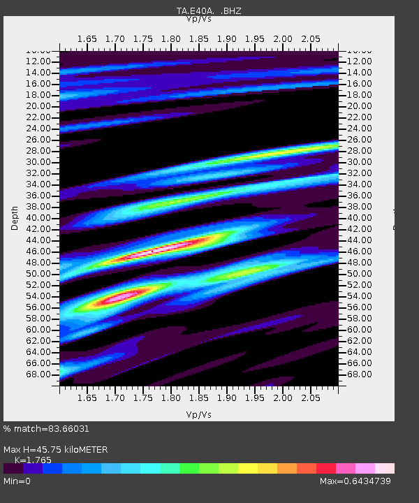
E40A Wakefield, MI, USA - Earthquake Result Viewer

Earthquake location: Near East Coast Of Honshu, Japan
Earthquake latitude/longitude: 36.3/141.3
Earthquake time(UTC): 2011/09/15 (258) 08:00:09 GMT
Earthquake Depth: 28 km
Earthquake Magnitude: 5.8 MB, 6.0 MS, 6.2 MW, 6.1 MW
Earthquake Catalog/Contributor: WHDF/NEIC
Network: TA USArray Transportable Network (new EarthScope stations)
Station: E40A Wakefield, MI, USA
Lat/Lon: 46.44 N/89.90 W
Elevation: 472 m
Distance: 85.7 deg
Az: 32.733 deg
Baz: 320.799 deg
Ray Param: 0.044561643
Estimated Moho Depth: 45.75 km
Estimated Crust Vp/Vs: 1.76
Assumed Crust Vp: 6.467 km/s
Estimated Crust Vs: 3.664 km/s
Estimated Crust Poisson's Ratio: 0.26
Radial Match: 83.66031 %
Radial Bump: 400
Transverse Match: 47.57483 %
Transverse Bump: 400
SOD ConfigId: 414626
Insert Time: 2012-01-23 11:59:35.717 +0000
GWidth: 2.5
Max Bumps: 400
Tol: 0.001

Signal To Noise

ChannelStoNSTALTA
TA:E40A: :BHZ:20110915T08:12:14.424973Z2.90058575.493381E-71.8938869E-7
TA:E40A: :BHN:20110915T08:12:14.424973Z2.10130292.1763006E-71.0356911E-7
TA:E40A: :BHE:20110915T08:12:14.424973Z1.79569451.9543256E-71.0883397E-7
Arrivals
Ps5.5 SECOND
PpPs19 SECOND
PsPs/PpSs25 SECOND