You are here: Home > Network List > BK - Berkeley Digital Seismograph Network Stations List
> Station HUMO Hull Mountain, OR > Earthquake Result Viewer
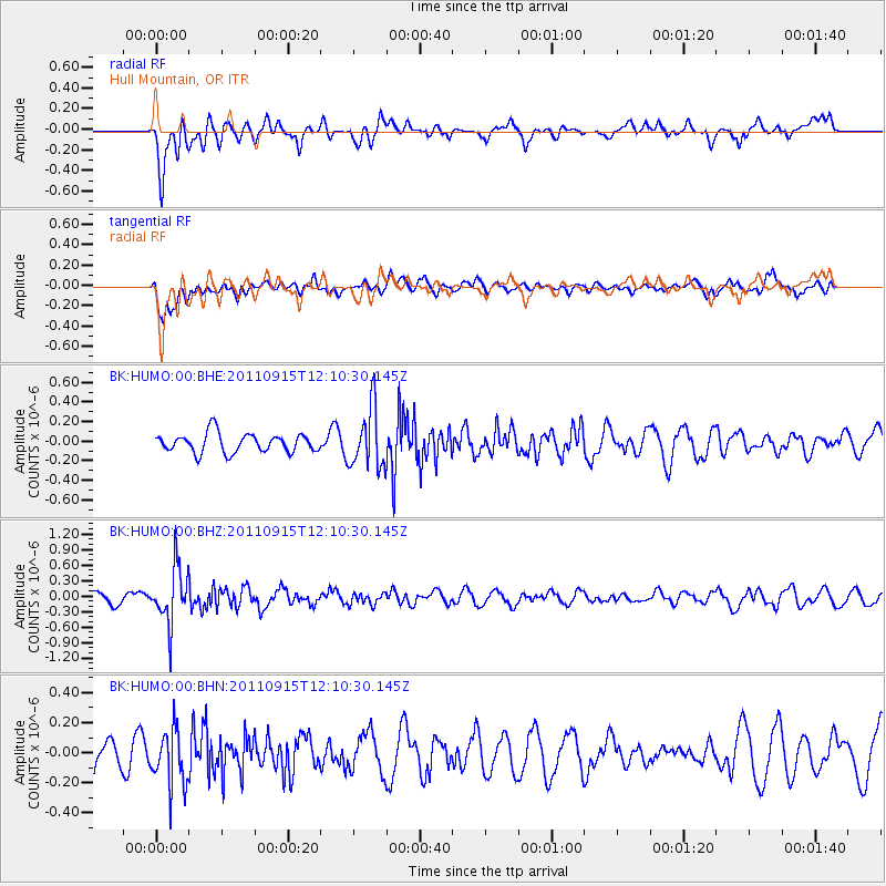
HUMO Hull Mountain, OR - Earthquake Result Viewer
*The percent match for this event was below the threshold and hence no stack was calculated.
| Earthquake location: |
Fiji Islands Region |
| Earthquake latitude/longitude: |
-15.0/-178.0 |
| Earthquake time(UTC): |
2011/09/15 (258) 11:59:52 GMT |
| Earthquake Depth: |
378 km |
| Earthquake Magnitude: |
5.6 MB, 5.6 MW, 5.5 MW |
| Earthquake Catalog/Contributor: |
WHDF/NEIC |
|
| Network: |
BK Berkeley Digital Seismograph Network |
| Station: |
HUMO Hull Mountain, OR |
| Lat/Lon: |
42.61 N/122.96 W |
| Elevation: |
555 m |
|
| Distance: |
76.3 deg |
| Az: |
38.491 deg |
| Baz: |
234.571 deg |
| Ray Param: |
$rayparam |
*The percent match for this event was below the threshold and hence was not used in the summary stack. |
|
| Radial Match: |
66.41422 % |
| Radial Bump: |
400 |
| Transverse Match: |
50.623165 % |
| Transverse Bump: |
400 |
| SOD ConfigId: |
414626 |
| Insert Time: |
2012-01-23 12:09:16.651 +0000 |
| GWidth: |
2.5 |
| Max Bumps: |
400 |
| Tol: |
0.001 |
|
Signal To Noise
| Channel | StoN | STA | LTA |
| BK:HUMO:00:BHZ:20110915T12:10:30.145Z | 4.410081 | 5.387747E-7 | 1.221689E-7 |
| BK:HUMO:00:BHN:20110915T12:10:30.145Z | 1.8443928 | 1.8526242E-7 | 1.004463E-7 |
| BK:HUMO:00:BHE:20110915T12:10:30.145Z | 3.1377559 | 3.0332228E-7 | 9.6668536E-8 |
| Arrivals |
| Ps | |
| PpPs | |
| PsPs/PpSs | |


