You are here: Home > Network List > TA - USArray Transportable Network (new EarthScope stations) Stations List
> Station MDND Maddock, ND, USA > Earthquake Result Viewer
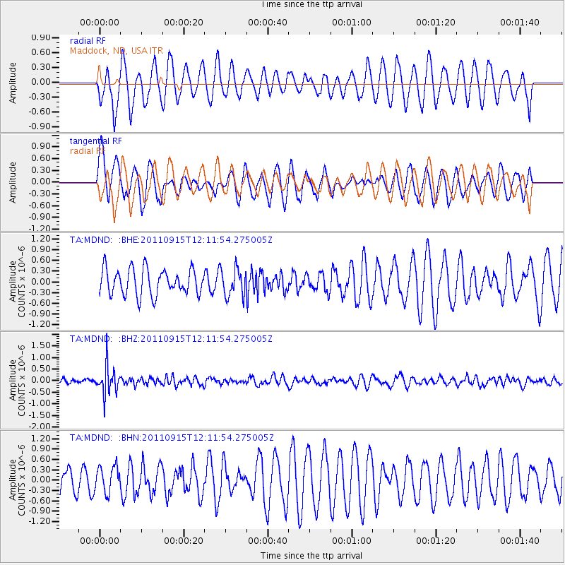
MDND Maddock, ND, USA - Earthquake Result Viewer
*The percent match for this event was below the threshold and hence no stack was calculated.
| Earthquake location: |
Fiji Islands Region |
| Earthquake latitude/longitude: |
-15.0/-178.0 |
| Earthquake time(UTC): |
2011/09/15 (258) 11:59:52 GMT |
| Earthquake Depth: |
378 km |
| Earthquake Magnitude: |
5.6 MB, 5.6 MW, 5.5 MW |
| Earthquake Catalog/Contributor: |
WHDF/NEIC |
|
| Network: |
TA USArray Transportable Network (new EarthScope stations) |
| Station: |
MDND Maddock, ND, USA |
| Lat/Lon: |
47.85 N/99.60 W |
| Elevation: |
479 m |
|
| Distance: |
93.3 deg |
| Az: |
41.363 deg |
| Baz: |
251.489 deg |
| Ray Param: |
$rayparam |
*The percent match for this event was below the threshold and hence was not used in the summary stack. |
|
| Radial Match: |
60.607525 % |
| Radial Bump: |
400 |
| Transverse Match: |
52.06114 % |
| Transverse Bump: |
400 |
| SOD ConfigId: |
414626 |
| Insert Time: |
2012-01-23 12:18:57.452 +0000 |
| GWidth: |
2.5 |
| Max Bumps: |
400 |
| Tol: |
0.001 |
|
Signal To Noise
| Channel | StoN | STA | LTA |
| TA:MDND: :BHZ:20110915T12:11:54.275005Z | 5.839987 | 6.178509E-7 | 1.0579663E-7 |
| TA:MDND: :BHN:20110915T12:11:54.275005Z | 1.0101345 | 3.8196865E-7 | 3.7813646E-7 |
| TA:MDND: :BHE:20110915T12:11:54.275005Z | 1.0323969 | 3.7257743E-7 | 3.6088582E-7 |
| Arrivals |
| Ps | |
| PpPs | |
| PsPs/PpSs | |


