You are here: Home > Network List > TA - USArray Transportable Network (new EarthScope stations) Stations List
> Station C06D Leavenworth, WQ, USA > Earthquake Result Viewer
C06D Leavenworth, WQ, USA - Earthquake Result Viewer
| Earthquake location: |
Solomon Islands |
| Earthquake latitude/longitude: |
-6.9/155.0 |
| Earthquake time(UTC): |
2014/04/11 (101) 08:23:45 GMT |
| Earthquake Depth: |
41 km |
| Earthquake Magnitude: |
5.1 mb |
| Earthquake Catalog/Contributor: |
ISC/ISC |
|
| Network: |
TA USArray Transportable Network (new EarthScope stations) |
| Station: |
C06D Leavenworth, WQ, USA |
| Lat/Lon: |
47.92 N/120.89 W |
| Elevation: |
544 m |
|
| Distance: |
91.1 deg |
| Az: |
42.002 deg |
| Baz: |
261.038 deg |
| Ray Param: |
0.04161958 |
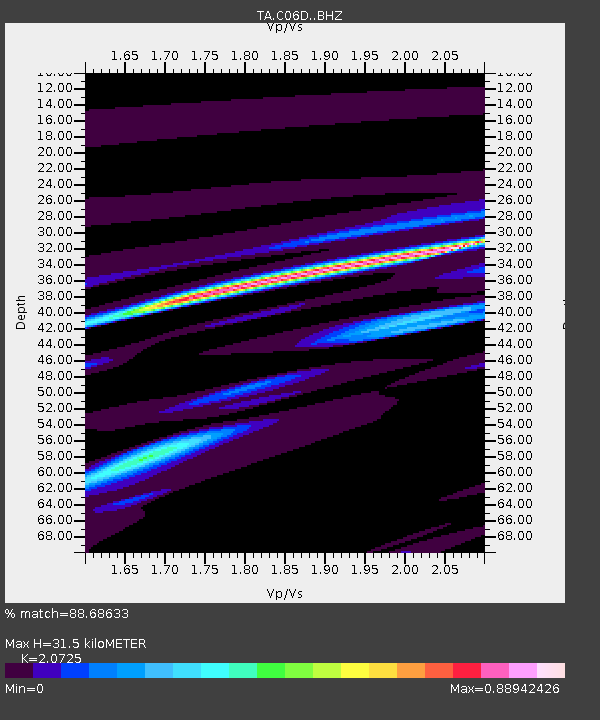
| Estimated Moho Depth: |
31.5 km |
| Estimated Crust Vp/Vs: |
2.07 |
| Assumed Crust Vp: |
6.597 km/s |
| Estimated Crust Vs: |
3.183 km/s |
| Estimated Crust Poisson's Ratio: |
0.35 |
|
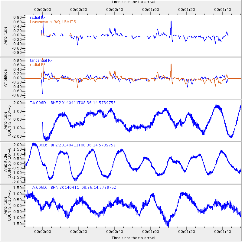
| Radial Match: |
88.68633 % |
| Radial Bump: |
289 |
| Transverse Match: |
50.22145 % |
| Transverse Bump: |
400 |
| SOD ConfigId: |
3390531 |
| Insert Time: |
2019-04-11 06:47:17.127 +0000 |
| GWidth: |
2.5 |
| Max Bumps: |
400 |
| Tol: |
0.001 |
|
Signal To Noise
| Channel | StoN | STA | LTA |
| TA:C06D: :BHZ:20140411T08:36:14.573975Z | 0.7200701 | 7.91297E-7 | 1.0989166E-6 |
| TA:C06D: :BHN:20140411T08:36:14.573975Z | 0.17940205 | 2.3076375E-7 | 1.2862937E-6 |
| TA:C06D: :BHE:20140411T08:36:14.573975Z | 1.4599835 | 1.3177802E-6 | 9.025994E-7 |
| Arrivals |
| Ps | 5.2 SECOND |
| PpPs | 14 SECOND |
| PsPs/PpSs | 20 SECOND |


