You are here: Home > Network List > TA - USArray Transportable Network (new EarthScope stations) Stations List
> Station 234A Clairette, TX, USA > Earthquake Result Viewer
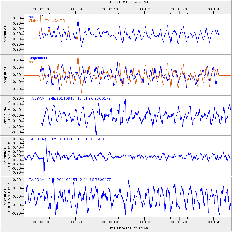
234A Clairette, TX, USA - Earthquake Result Viewer
*The percent match for this event was below the threshold and hence no stack was calculated.
| Earthquake location: |
Fiji Islands Region |
| Earthquake latitude/longitude: |
-15.0/-178.0 |
| Earthquake time(UTC): |
2011/09/15 (258) 11:59:52 GMT |
| Earthquake Depth: |
378 km |
| Earthquake Magnitude: |
5.6 MB, 5.6 MW, 5.5 MW |
| Earthquake Catalog/Contributor: |
WHDF/NEIC |
|
| Network: |
TA USArray Transportable Network (new EarthScope stations) |
| Station: |
234A Clairette, TX, USA |
| Lat/Lon: |
32.00 N/98.14 W |
| Elevation: |
358 m |
|
| Distance: |
89.4 deg |
| Az: |
56.748 deg |
| Baz: |
252.061 deg |
| Ray Param: |
$rayparam |
*The percent match for this event was below the threshold and hence was not used in the summary stack. |
|
| Radial Match: |
60.427467 % |
| Radial Bump: |
400 |
| Transverse Match: |
53.136707 % |
| Transverse Bump: |
400 |
| SOD ConfigId: |
414626 |
| Insert Time: |
2012-01-23 12:21:23.452 +0000 |
| GWidth: |
2.5 |
| Max Bumps: |
400 |
| Tol: |
0.001 |
|
Signal To Noise
| Channel | StoN | STA | LTA |
| TA:234A: :BHZ:20110915T12:11:36.350017Z | 4.3103824 | 3.745675E-7 | 8.689891E-8 |
| TA:234A: :BHN:20110915T12:11:36.350017Z | 0.7031743 | 5.7180177E-8 | 8.131722E-8 |
| TA:234A: :BHE:20110915T12:11:36.350017Z | 1.5622151 | 1.4646757E-7 | 9.375634E-8 |
| Arrivals |
| Ps | |
| PpPs | |
| PsPs/PpSs | |


