You are here: Home > Network List > TA - USArray Transportable Network (new EarthScope stations) Stations List
> Station L35A Bielow Farm, Ricketts, IA, USA > Earthquake Result Viewer
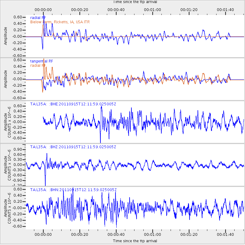
L35A Bielow Farm, Ricketts, IA, USA - Earthquake Result Viewer
*The percent match for this event was below the threshold and hence no stack was calculated.
| Earthquake location: |
Fiji Islands Region |
| Earthquake latitude/longitude: |
-15.0/-178.0 |
| Earthquake time(UTC): |
2011/09/15 (258) 11:59:52 GMT |
| Earthquake Depth: |
378 km |
| Earthquake Magnitude: |
5.6 MB, 5.6 MW, 5.5 MW |
| Earthquake Catalog/Contributor: |
WHDF/NEIC |
|
| Network: |
TA USArray Transportable Network (new EarthScope stations) |
| Station: |
L35A Bielow Farm, Ricketts, IA, USA |
| Lat/Lon: |
42.11 N/95.54 W |
| Elevation: |
410 m |
|
| Distance: |
94.4 deg |
| Az: |
47.707 deg |
| Baz: |
253.924 deg |
| Ray Param: |
$rayparam |
*The percent match for this event was below the threshold and hence was not used in the summary stack. |
|
| Radial Match: |
60.15165 % |
| Radial Bump: |
400 |
| Transverse Match: |
57.989685 % |
| Transverse Bump: |
400 |
| SOD ConfigId: |
414626 |
| Insert Time: |
2012-01-23 12:28:36.345 +0000 |
| GWidth: |
2.5 |
| Max Bumps: |
400 |
| Tol: |
0.001 |
|
Signal To Noise
| Channel | StoN | STA | LTA |
| TA:L35A: :BHZ:20110915T12:11:59.025005Z | 2.994782 | 3.2253757E-7 | 1.0769985E-7 |
| TA:L35A: :BHN:20110915T12:11:59.025005Z | 1.632676 | 1.8151913E-7 | 1.111789E-7 |
| TA:L35A: :BHE:20110915T12:11:59.025005Z | 2.177079 | 2.740634E-7 | 1.2588583E-7 |
| Arrivals |
| Ps | |
| PpPs | |
| PsPs/PpSs | |


