You are here: Home > Network List > TA - USArray Transportable Network (new EarthScope stations) Stations List
> Station V37A Hulbert, OK, USA > Earthquake Result Viewer
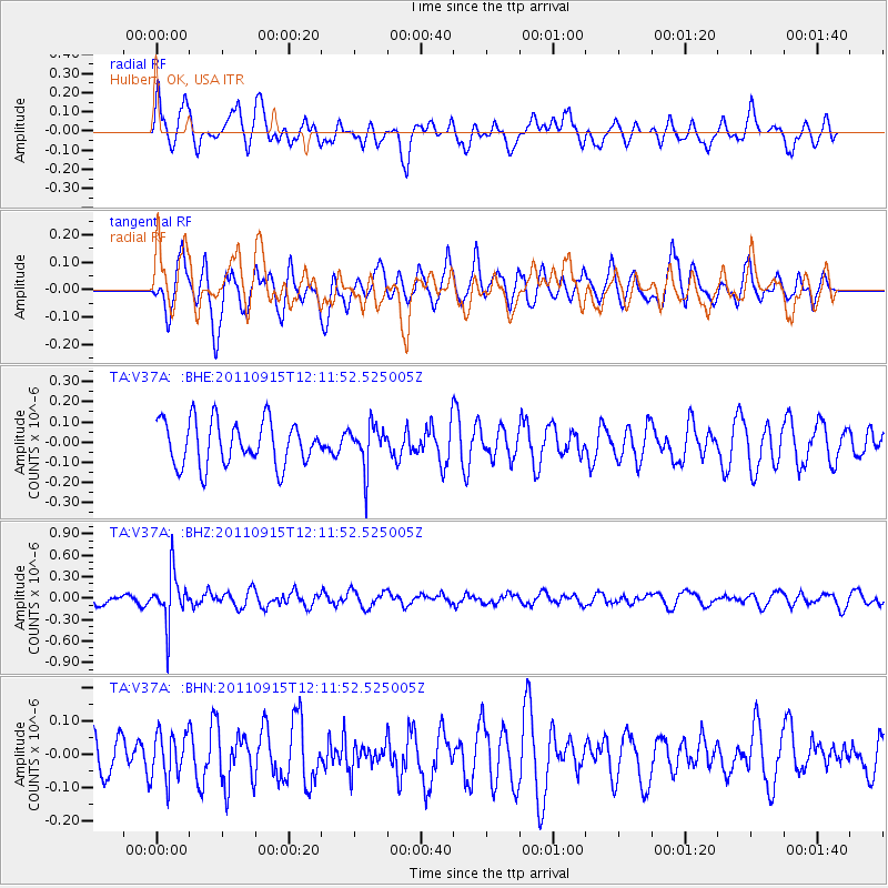
V37A Hulbert, OK, USA - Earthquake Result Viewer
*The percent match for this event was below the threshold and hence no stack was calculated.
| Earthquake location: |
Fiji Islands Region |
| Earthquake latitude/longitude: |
-15.0/-178.0 |
| Earthquake time(UTC): |
2011/09/15 (258) 11:59:52 GMT |
| Earthquake Depth: |
378 km |
| Earthquake Magnitude: |
5.6 MB, 5.6 MW, 5.5 MW |
| Earthquake Catalog/Contributor: |
WHDF/NEIC |
|
| Network: |
TA USArray Transportable Network (new EarthScope stations) |
| Station: |
V37A Hulbert, OK, USA |
| Lat/Lon: |
35.88 N/95.14 W |
| Elevation: |
219 m |
|
| Distance: |
93.0 deg |
| Az: |
53.782 deg |
| Baz: |
253.789 deg |
| Ray Param: |
$rayparam |
*The percent match for this event was below the threshold and hence was not used in the summary stack. |
|
| Radial Match: |
58.55829 % |
| Radial Bump: |
400 |
| Transverse Match: |
63.401886 % |
| Transverse Bump: |
400 |
| SOD ConfigId: |
414626 |
| Insert Time: |
2012-01-23 12:29:02.573 +0000 |
| GWidth: |
2.5 |
| Max Bumps: |
400 |
| Tol: |
0.001 |
|
Signal To Noise
| Channel | StoN | STA | LTA |
| TA:V37A: :BHZ:20110915T12:11:52.525005Z | 4.766039 | 3.4633115E-7 | 7.266645E-8 |
| TA:V37A: :BHN:20110915T12:11:52.525005Z | 1.4224757 | 6.939551E-8 | 4.8785022E-8 |
| TA:V37A: :BHE:20110915T12:11:52.525005Z | 0.9906109 | 1.0798529E-7 | 1.0900878E-7 |
| Arrivals |
| Ps | |
| PpPs | |
| PsPs/PpSs | |


