You are here: Home > Network List > TA - USArray Transportable Network (new EarthScope stations) Stations List
> Station C35A Jirik Farms, Max, MN, USA > Earthquake Result Viewer
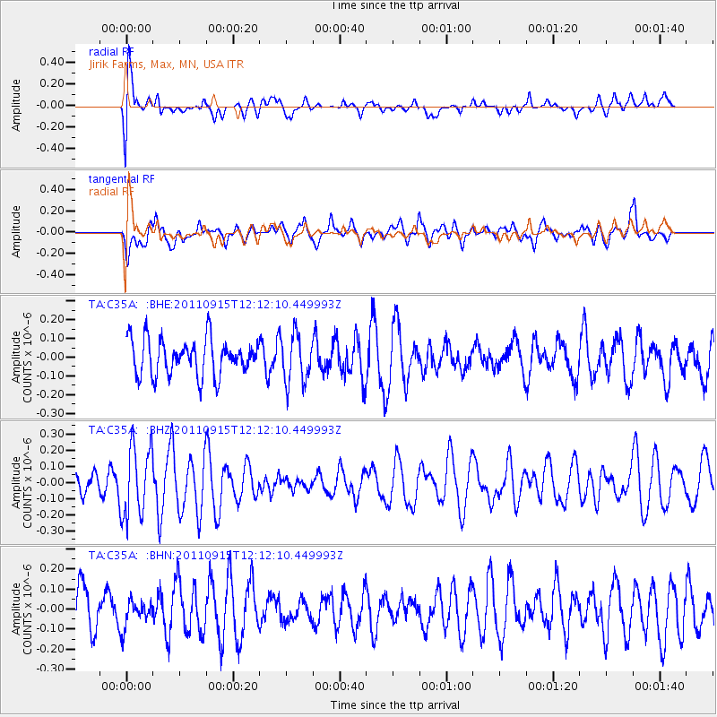
C35A Jirik Farms, Max, MN, USA - Earthquake Result Viewer
*The percent match for this event was below the threshold and hence no stack was calculated.
| Earthquake location: |
Fiji Islands Region |
| Earthquake latitude/longitude: |
-15.0/-178.0 |
| Earthquake time(UTC): |
2011/09/15 (258) 11:59:52 GMT |
| Earthquake Depth: |
378 km |
| Earthquake Magnitude: |
5.6 MB, 5.6 MW, 5.5 MW |
| Earthquake Catalog/Contributor: |
WHDF/NEIC |
|
| Network: |
TA USArray Transportable Network (new EarthScope stations) |
| Station: |
C35A Jirik Farms, Max, MN, USA |
| Lat/Lon: |
47.70 N/93.98 W |
| Elevation: |
426 m |
|
| Distance: |
96.9 deg |
| Az: |
42.586 deg |
| Baz: |
255.534 deg |
| Ray Param: |
$rayparam |
*The percent match for this event was below the threshold and hence was not used in the summary stack. |
|
| Radial Match: |
67.73379 % |
| Radial Bump: |
400 |
| Transverse Match: |
55.049717 % |
| Transverse Bump: |
400 |
| SOD ConfigId: |
414626 |
| Insert Time: |
2012-01-23 12:33:21.222 +0000 |
| GWidth: |
2.5 |
| Max Bumps: |
400 |
| Tol: |
0.001 |
|
Signal To Noise
| Channel | StoN | STA | LTA |
| TA:C35A: :BHZ:20110915T12:12:10.449993Z | 2.841653 | 2.1555624E-7 | 7.585593E-8 |
| TA:C35A: :BHN:20110915T12:12:10.449993Z | 0.6912861 | 6.88193E-8 | 9.9552565E-8 |
| TA:C35A: :BHE:20110915T12:12:10.449993Z | 1.3260198 | 1.2690698E-7 | 9.5705204E-8 |
| Arrivals |
| Ps | |
| PpPs | |
| PsPs/PpSs | |


