You are here: Home > Network List > TA - USArray Transportable Network (new EarthScope stations) Stations List
> Station K37A Belmond, IA, USA > Earthquake Result Viewer
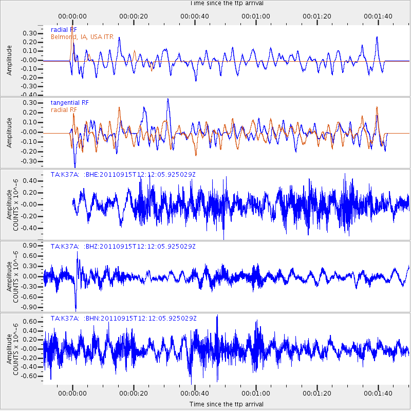
K37A Belmond, IA, USA - Earthquake Result Viewer
*The percent match for this event was below the threshold and hence no stack was calculated.
| Earthquake location: |
Fiji Islands Region |
| Earthquake latitude/longitude: |
-15.0/-178.0 |
| Earthquake time(UTC): |
2011/09/15 (258) 11:59:52 GMT |
| Earthquake Depth: |
378 km |
| Earthquake Magnitude: |
5.6 MB, 5.6 MW, 5.5 MW |
| Earthquake Catalog/Contributor: |
WHDF/NEIC |
|
| Network: |
TA USArray Transportable Network (new EarthScope stations) |
| Station: |
K37A Belmond, IA, USA |
| Lat/Lon: |
42.77 N/93.64 W |
| Elevation: |
365 m |
|
| Distance: |
95.9 deg |
| Az: |
47.451 deg |
| Baz: |
255.229 deg |
| Ray Param: |
$rayparam |
*The percent match for this event was below the threshold and hence was not used in the summary stack. |
|
| Radial Match: |
60.598648 % |
| Radial Bump: |
400 |
| Transverse Match: |
59.058647 % |
| Transverse Bump: |
400 |
| SOD ConfigId: |
414626 |
| Insert Time: |
2012-01-23 12:33:48.651 +0000 |
| GWidth: |
2.5 |
| Max Bumps: |
400 |
| Tol: |
0.001 |
|
Signal To Noise
| Channel | StoN | STA | LTA |
| TA:K37A: :BHZ:20110915T12:12:05.925029Z | 3.2616858 | 3.1176003E-7 | 9.5582486E-8 |
| TA:K37A: :BHN:20110915T12:12:05.925029Z | 1.2247403 | 1.5031182E-7 | 1.2272955E-7 |
| TA:K37A: :BHE:20110915T12:12:05.925029Z | 0.93288064 | 1.3039683E-7 | 1.3977868E-7 |
| Arrivals |
| Ps | |
| PpPs | |
| PsPs/PpSs | |


