You are here: Home > Network List > TA - USArray Transportable Network (new EarthScope stations) Stations List
> Station V39A Pettigrew, AR, USA > Earthquake Result Viewer
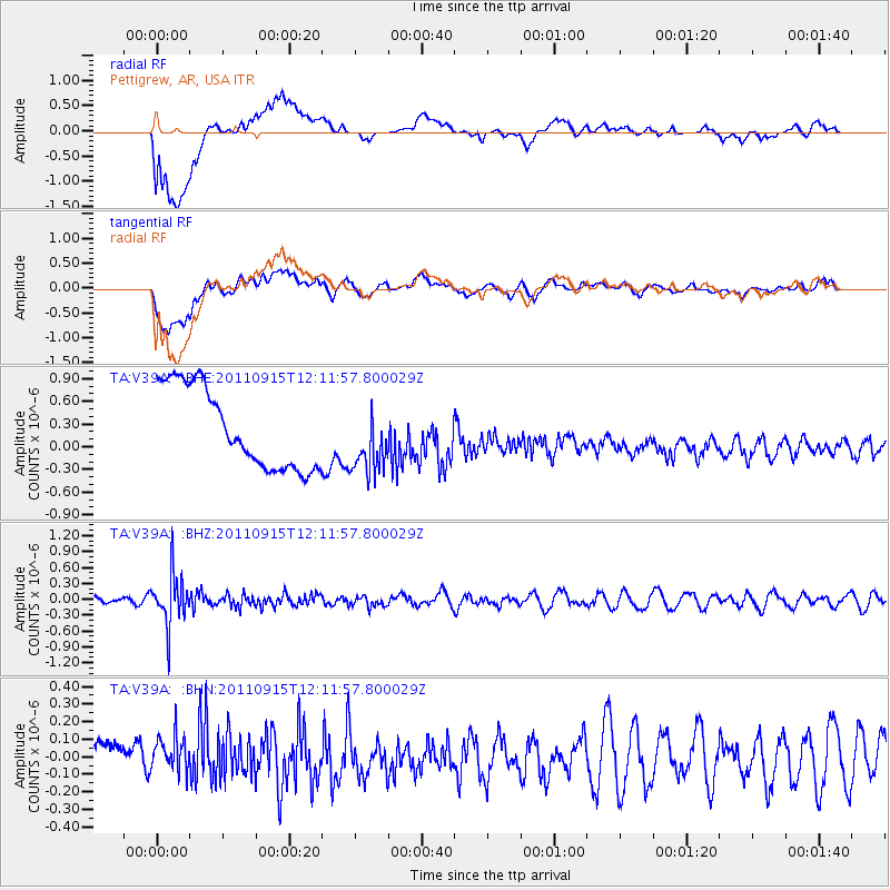
V39A Pettigrew, AR, USA - Earthquake Result Viewer
*The percent match for this event was below the threshold and hence no stack was calculated.
| Earthquake location: |
Fiji Islands Region |
| Earthquake latitude/longitude: |
-15.0/-178.0 |
| Earthquake time(UTC): |
2011/09/15 (258) 11:59:52 GMT |
| Earthquake Depth: |
378 km |
| Earthquake Magnitude: |
5.6 MB, 5.6 MW, 5.5 MW |
| Earthquake Catalog/Contributor: |
WHDF/NEIC |
|
| Network: |
TA USArray Transportable Network (new EarthScope stations) |
| Station: |
V39A Pettigrew, AR, USA |
| Lat/Lon: |
35.84 N/93.64 W |
| Elevation: |
744 m |
|
| Distance: |
94.1 deg |
| Az: |
54.156 deg |
| Baz: |
254.639 deg |
| Ray Param: |
$rayparam |
*The percent match for this event was below the threshold and hence was not used in the summary stack. |
|
| Radial Match: |
41.987007 % |
| Radial Bump: |
400 |
| Transverse Match: |
50.46793 % |
| Transverse Bump: |
400 |
| SOD ConfigId: |
414626 |
| Insert Time: |
2012-01-23 12:37:13.649 +0000 |
| GWidth: |
2.5 |
| Max Bumps: |
400 |
| Tol: |
0.001 |
|
Signal To Noise
| Channel | StoN | STA | LTA |
| TA:V39A: :BHZ:20110915T12:11:57.800029Z | 6.3213124 | 4.779936E-7 | 7.561619E-8 |
| TA:V39A: :BHN:20110915T12:11:57.800029Z | 0.8893401 | 1.3011221E-7 | 1.4630197E-7 |
| TA:V39A: :BHE:20110915T12:11:57.800029Z | 0.8264057 | 4.4036815E-7 | 5.3287164E-7 |
| Arrivals |
| Ps | |
| PpPs | |
| PsPs/PpSs | |


