You are here: Home > Network List > TA - USArray Transportable Network (new EarthScope stations) Stations List
> Station Y42A Garnett, Star City, AR, USA > Earthquake Result Viewer
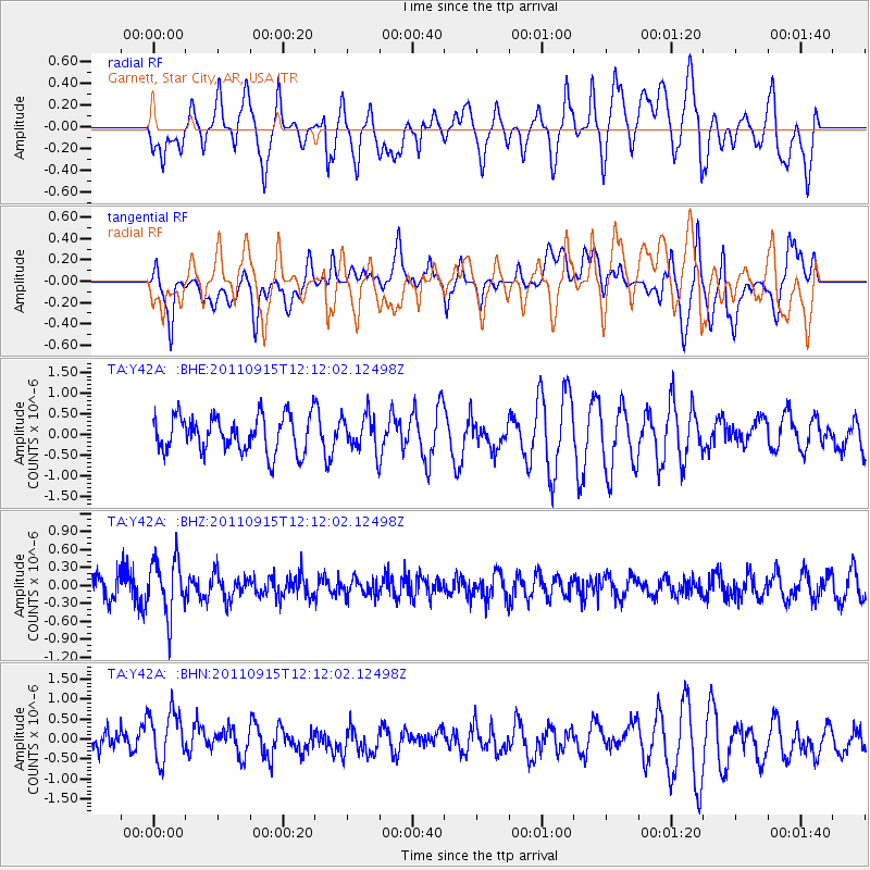
Y42A Garnett, Star City, AR, USA - Earthquake Result Viewer
*The percent match for this event was below the threshold and hence no stack was calculated.
| Earthquake location: |
Fiji Islands Region |
| Earthquake latitude/longitude: |
-15.0/-178.0 |
| Earthquake time(UTC): |
2011/09/15 (258) 11:59:52 GMT |
| Earthquake Depth: |
378 km |
| Earthquake Magnitude: |
5.6 MB, 5.6 MW, 5.5 MW |
| Earthquake Catalog/Contributor: |
WHDF/NEIC |
|
| Network: |
TA USArray Transportable Network (new EarthScope stations) |
| Station: |
Y42A Garnett, Star City, AR, USA |
| Lat/Lon: |
33.84 N/91.79 W |
| Elevation: |
77 m |
|
| Distance: |
95.1 deg |
| Az: |
56.487 deg |
| Baz: |
255.509 deg |
| Ray Param: |
$rayparam |
*The percent match for this event was below the threshold and hence was not used in the summary stack. |
|
| Radial Match: |
48.45983 % |
| Radial Bump: |
400 |
| Transverse Match: |
65.27418 % |
| Transverse Bump: |
400 |
| SOD ConfigId: |
414626 |
| Insert Time: |
2012-01-23 12:38:04.337 +0000 |
| GWidth: |
2.5 |
| Max Bumps: |
400 |
| Tol: |
0.001 |
|
Signal To Noise
| Channel | StoN | STA | LTA |
| TA:Y42A: :BHZ:20110915T12:12:02.12498Z | 2.1020923 | 4.6683277E-7 | 2.2208006E-7 |
| TA:Y42A: :BHN:20110915T12:12:02.12498Z | 1.5412159 | 6.859551E-7 | 4.4507397E-7 |
| TA:Y42A: :BHE:20110915T12:12:02.12498Z | 0.9797188 | 4.319946E-7 | 4.4093736E-7 |
| Arrivals |
| Ps | |
| PpPs | |
| PsPs/PpSs | |


