You are here: Home > Network List > TA - USArray Transportable Network (new EarthScope stations) Stations List
> Station T41A Mountain View, MO, USA > Earthquake Result Viewer
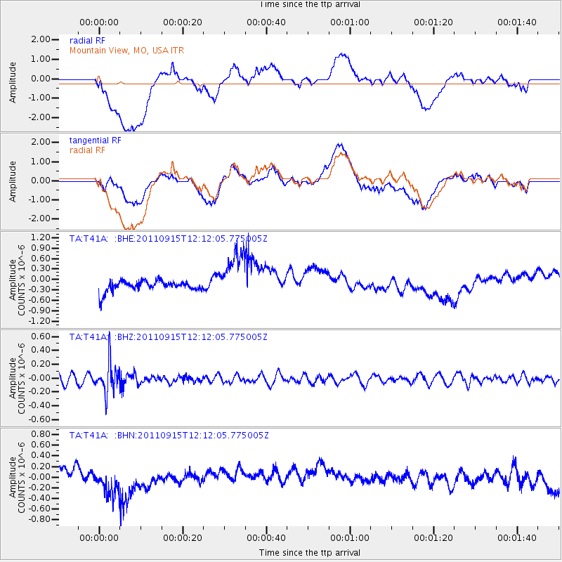
T41A Mountain View, MO, USA - Earthquake Result Viewer
*The percent match for this event was below the threshold and hence no stack was calculated.
| Earthquake location: |
Fiji Islands Region |
| Earthquake latitude/longitude: |
-15.0/-178.0 |
| Earthquake time(UTC): |
2011/09/15 (258) 11:59:52 GMT |
| Earthquake Depth: |
378 km |
| Earthquake Magnitude: |
5.6 MB, 5.6 MW, 5.5 MW |
| Earthquake Catalog/Contributor: |
WHDF/NEIC |
|
| Network: |
TA USArray Transportable Network (new EarthScope stations) |
| Station: |
T41A Mountain View, MO, USA |
| Lat/Lon: |
37.04 N/91.76 W |
| Elevation: |
366 m |
|
| Distance: |
95.9 deg |
| Az: |
53.377 deg |
| Baz: |
255.819 deg |
| Ray Param: |
$rayparam |
*The percent match for this event was below the threshold and hence was not used in the summary stack. |
|
| Radial Match: |
22.670109 % |
| Radial Bump: |
400 |
| Transverse Match: |
21.496752 % |
| Transverse Bump: |
400 |
| SOD ConfigId: |
414626 |
| Insert Time: |
2012-01-23 12:38:33.670 +0000 |
| GWidth: |
2.5 |
| Max Bumps: |
400 |
| Tol: |
0.001 |
|
Signal To Noise
| Channel | StoN | STA | LTA |
| TA:T41A: :BHZ:20110915T12:12:05.775005Z | 3.5889423 | 2.2676876E-7 | 6.3185404E-8 |
| TA:T41A: :BHN:20110915T12:12:05.775005Z | 0.7227806 | 1.733412E-7 | 2.3982548E-7 |
| TA:T41A: :BHE:20110915T12:12:05.775005Z | 4.7169666 | 7.132855E-7 | 1.51217E-7 |
| Arrivals |
| Ps | |
| PpPs | |
| PsPs/PpSs | |


