You are here: Home > Network List > AU - Australian Seismological Centre Stations List
> Station MAW Mawson, Antarctica > Earthquake Result Viewer
MAW Mawson, Antarctica - Earthquake Result Viewer
| Earthquake location: |
Fiji Islands Region |
| Earthquake latitude/longitude: |
-21.6/-179.5 |
| Earthquake time(UTC): |
2011/09/15 (258) 19:31:04 GMT |
| Earthquake Depth: |
645 km |
| Earthquake Magnitude: |
6.1 MB, 7.3 MW, 7.3 MW |
| Earthquake Catalog/Contributor: |
WHDF/NEIC |
|
| Network: |
AU Australian Seismological Centre |
| Station: |
MAW Mawson, Antarctica |
| Lat/Lon: |
67.60 S/62.87 E |
| Elevation: |
12 m |
|
| Distance: |
80.0 deg |
| Az: |
200.169 deg |
| Baz: |
123.147 deg |
| Ray Param: |
0.04651608 |
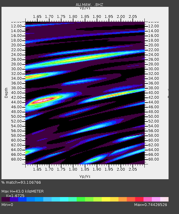
| Estimated Moho Depth: |
43.0 km |
| Estimated Crust Vp/Vs: |
1.67 |
| Assumed Crust Vp: |
6.508 km/s |
| Estimated Crust Vs: |
3.891 km/s |
| Estimated Crust Poisson's Ratio: |
0.22 |
|
| Radial Match: |
93.106766 % |
| Radial Bump: |
400 |
| Transverse Match: |
88.8755 % |
| Transverse Bump: |
400 |
| SOD ConfigId: |
414626 |
| Insert Time: |
2012-01-23 12:49:59.762 +0000 |
| GWidth: |
2.5 |
| Max Bumps: |
400 |
| Tol: |
0.001 |
|

Signal To Noise
| Channel | StoN | STA | LTA |
| AU:MAW: :BHZ:20110915T19:41:37.512983Z | 47.78069 | 7.7191885E-7 | 1.6155457E-8 |
| AU:MAW: :BHN:20110915T19:41:37.512983Z | 9.675938 | 1.6874496E-7 | 1.743965E-8 |
| AU:MAW: :BHE:20110915T19:41:37.512983Z | 29.38722 | 2.3162535E-7 | 7.881839E-9 |
| Arrivals |
| Ps | 4.6 SECOND |
| PpPs | 17 SECOND |
| PsPs/PpSs | 22 SECOND |


